
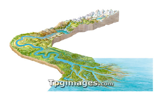
Stages of a river. Artwork showing the course of a river from the mountains (snow-covered, upper right) down to the sea (lower right). The river is fed by meltwater from mountain snows and glaciers, forming lakes (upper right). In the mountains, the river is narrow and fast, carving steep valleys and falling over waterfalls (upper centre) and through rapids (upper left). As the river reaches more level ground, it widens and begins to meander (centre left). In times of flood it deposits its sediment, eroded from the mountain rock, forming an alluvial floodplain that can be farmed (layers of sediment at lower left, mountain rock layers at upper right). As the river reaches the sea, its flow slows further and its sediment forms a delta.
| px | px | dpi | = | cm | x | cm | = | MB |
Details
Creative#:
TOP03208361
Source:
達志影像
Authorization Type:
RM
Release Information:
須由TPG 完整授權
Model Release:
N/A
Property Release:
N/A
Right to Privacy:
No
Same folder images:
 Loading