
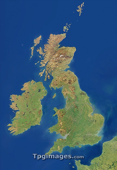
British Isles, satellite image. North is at top. This mosaic of cloud-free satellite images shows the British Isles, including the Orkney, Shetland and the Channel Islands as well as the UK and Ireland. The data used in this image has been obtained by the MODIS instrument on NASA's Terra satellite.
| px | px | dpi | = | cm | x | cm | = | MB |
Details
Creative#:
TOP06662666
Source:
達志影像
Authorization Type:
RM
Release Information:
須由TPG 完整授權
Model Release:
NO
Property Release:
NO
Right to Privacy:
No
Same folder images:
britishislesirelandunitedkingdomukbritaingreatbritaincountrynationstateislandatlanticoceaneuropegeographyearthobservationsatelliteimagesatellitemodisterrafromspacegeographicalislandsisleislesenglishirishscottishwelshwalesscotlandeireenglandeuropeancloud-freecloudfreecloudlessnaturenaturalcolourlandseawatercoastalcoastcoastlinecoastlinesmountainmountainsvegetationmoderate-resolutionimagingspectroradiometer"
"atlanticbritainbritainbritishcloudcloud-freecloudlesscoastcoastalcoastlinecoastlinescolourcountryeartheireenglandenglisheuropeeuropeanfreefromgeographicalgeographygreatimageimagingirelandirishislandislandsisleislesisleskingdomlandmoderate-resolutionmodismountainmountainsnationnaturalnatureobservationoceansatellitesatellitescotlandscottishseaspacespectroradiometerstateterraukunitedvegetationwaleswaterwelsh
 Loading