
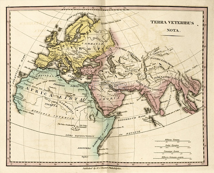
Map of the Ancient World, 19th century. This map is divided by colour into Europe (yellow), Asia (pink) and Africa (green) and labelled with the names of regions and states of antiquity. The distance scales (lower right) are in Roman miles, Greek stadia, Persian parasangs, and British miles. Published in 'An Atlas of Ancient Geography' (1826) by US cartographer Henry Schenck Tanner (1786-1858).
| px | px | dpi | = | cm | x | cm | = | MB |
Details
Creative#:
TOP16426050
Source:
達志影像
Authorization Type:
RM
Release Information:
須由TPG 完整授權
Model Release:
N/A
Property Release:
N/A
Right to Privacy:
No
Same folder images:
1800s182619thcenturyaethiopiaafricaafricananatlasofancientgeographyancientworldantiquaantiquityarabiaartworkasiaasiaminorasianatlasbelgiumbookbritanniabritishmilescartographyclassicaldaciadistancescaleegyptempireempireseuropaeuropeeuropeangaulgeographicalgeographygermaniagreecegreekstadiahenryschencktannerhiberniahispaniahistoricalhistoryillustrationindiaitaliaitalylatinlibyamapmareinternummauretaniamauritaniamediterraneanseamilliariabritannicapropriamilliariaromanano-onenobodypageparasangaepersicaepersiapersianparasangspontuseuxinuspublicationregionregionsromanmilessarmatiascalesscandinaviascythiastadiaolympicastatestatesterraveteribusnotaturkey
1800s182619thaethiopiaafricaafricananancientancientantiquaantiquityarabiaartworkasiaasiaasianatlasatlasbelgiumbookbritanniabritannicabritishcartographycenturyclassicaldaciadistanceegyptempireempireseuropaeuropeeuropeaneuxinusgaulgeographicalgeographygeographygermaniagreecegreekhenryhiberniahispaniahistoricalhistoryillustrationindiainternumitaliaitalylatinlibyamapmaremauretaniamauritaniamediterraneanmilesmilesmilliariamilliariaminorno-onenobodynotaofolympicapageparasangaeparasangspersiapersianpersicaepontuspropriapublicationregionregionsromanromanasarmatiascalescalesscandinaviaschenckscythiaseastadiastadiastatestatestannerterraturkeyveteribusworld
 Loading