
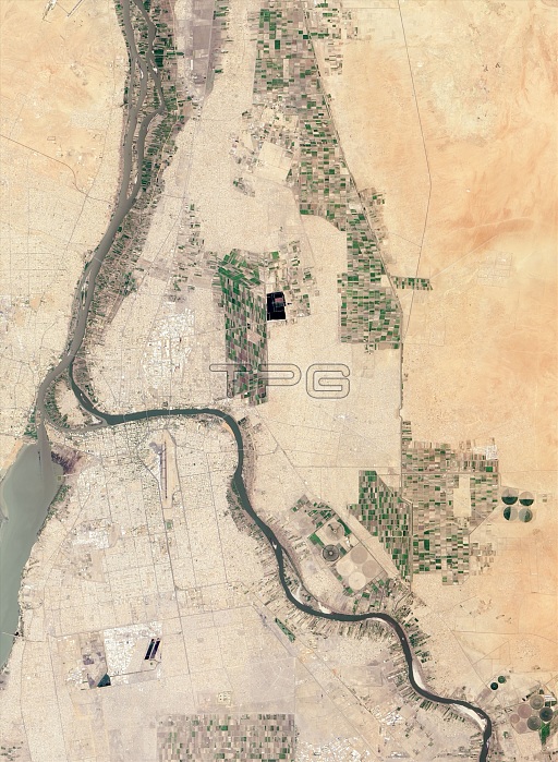
Khartoum. Satellite image of the city of Khartoum (centre left), Sudan, and the surrounding area, showing the Blue Nile (diagonal left to lower right) and White Nile (top left to bottom left), near the end of the region's dry season. These two rivers are the main tributaries of the Nile. Patchworks of croplands (including centre-pivot irrigated fields) can also be seen dotting the city's outskirts. Imaged by the Advanced Land Imager (ALI) on NASA's Earth Observing-1 (EO-1) satellite, on 26th August 2013.
| px | px | dpi | = | cm | x | cm | = | MB |
Details
Creative#:
TOP16634174
Source:
達志影像
Authorization Type:
RM
Release Information:
須由TPG 完整授權
Model Release:
N/A
Property Release:
N/A
Right to Privacy:
No
Same folder images:
201321stcentury26august26/08/201326thadvancedlandimagerafricaafricanagriculturalagriculturealibluenilecitycroplandcroplandsdryseasonearthobservationearthobserving-1environmentenvironmentalscienceeo-1farmfarmingfieldfieldsfromabovefromspacegeographicalgeographyhydrologicalhydrologyirrigatedirrigationkhartoumlandusemeetingpointnileno-onenobodypatchworkriverriversruralsatellitesatelliteimagesudantributariestributaryurbanwaterwhite
26201321st26/08/201326thaboveadvancedafricaafricanagriculturalagriculturealiaugustbluecenturycitycroplandcroplandsdryearthearthenvironmentenvironmentaleo-1farmfarmingfieldfieldsfromfromgeographicalgeographyhydrologicalhydrologyimageimagerirrigatedirrigationkhartoumlandlandmeetingnilenileno-onenobodyobservationobserving-1patchworkpointriverriversruralsatellitesatellitescienceseasonspacesudantributariestributaryurbanusewaterwhite
 Loading