
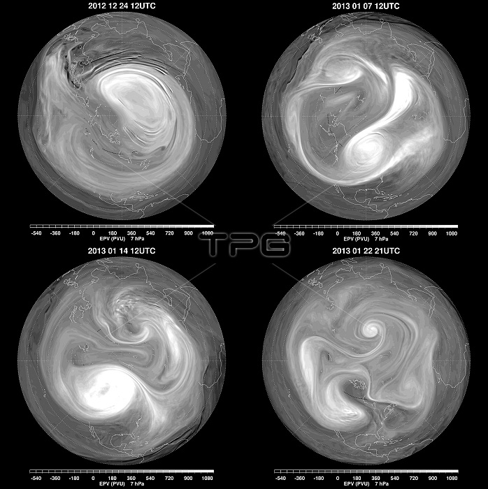
These images are data models from NASA's GEOS-5 showing Ertel's Potential Vorticity in potential vorticity units (PVU). The shading shows regions of high EPV, typical of the polar vortex, in white, and regions of low EPV, typical of tropical air masses, in darker shades. In the first image (top left) depict a strong, elongated polar vortex over northern Europe and Asia. By January 7, the shearing of the original polar vortex by the winds led to the existence of three smaller, interconnected vortices (top right), located over Canada, northern Eurasia, and northeastern Siberia. By January 14, the weakest of these vortices (over Siberia) disappeared (bottom left). At this time, the vortex located over Canada was the stronger of the pair, but with the low EPV values remaining over the pole, the high-latitude stratosphere was still anomalously warm. Further stretching and shearing of the vortices occurred, leading to a situation with no well-formed polar vortex for several days. By January 22 (bottom right), the flow appeared to be reorganizing, with a broad region of cyclonic circulation developing near the pole.
| px | px | dpi | = | cm | x | cm | = | MB |
Details
Creative#:
TOP22093018
Source:
達志影像
Authorization Type:
RM
Release Information:
須由TPG 完整授權
Model Release:
N/A
Property Release:
No
Right to Privacy:
No
Same folder images:
 Loading