
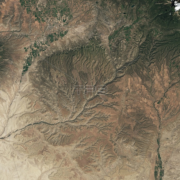
Mesa Verde National Park, Colorado, and its surroundings, as seen by the Operational Land Imager (OLI) on the Landsat 8 satellite on August 15, 2016. Mesa Verde isn't actually a mesa, geologically speaking. It is a cuesta, a flat highland with a gentle slope in one direction. Streams cut into the sandstones and shales of the slope, forming all the canyons and alcoves seen in the park today.
| px | px | dpi | = | cm | x | cm | = | MB |
Details
Creative#:
TOP22096288
Source:
達志影像
Authorization Type:
RM
Release Information:
須由TPG 完整授權
Model Release:
N/A
Property Release:
No
Right to Privacy:
No
Same folder images:
drainagepatterndendriticbranchingsanjuanriverrivererosionsandstonerockcanyonlandhighlandsdissectedtablelandtopographictopographygeographicgeography2016imageryobservationlandsatphotosatellitephotographyaerialearthfromspaceearthsciencelandscapelandformgeologicalfeaturegeologicformationgeologyoperationallandimagerolilandsat8northamericaamericanwestunitedstatesusawesternuscoloradoplateaumesaverderegionstreamchannelrivervalleycuestamesaverdenationalparklandsataerialviewsatelliteimagecoloradomesaverde
82016aerialaerialamericaamericanbranchingcanyonlandchannelcoloradocoloradocuestadendriticdissecteddrainageeartheartherosionfeatureformationfromgeographicgeographygeologicgeologicalgeologyhighlandsimageimagerimageryjuanlandlandformlandsatlandsatlandsatlandscapemesamesamesanationalnorthobservationolioperationalparkpatternphotophotographyplateauregionriverriverriverrocksansandstonesatellitesatellitesciencespacestatesstreamtablelandtopographictopographyunitedususavalleyverdeverdeverdeviewwestwestern
 Loading