
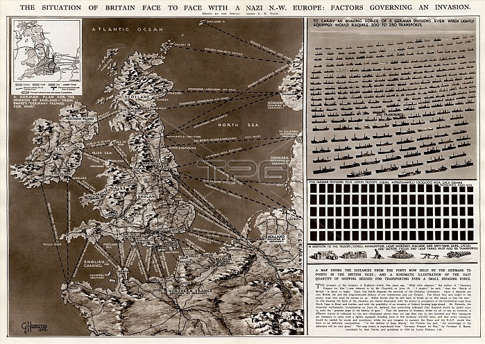
The situation of Britain face to face with a German north-west Europe: factors governing an invasion during the Second World War. A map giving the distances from the ports held by the Germans to points in the British Isles, and a schematic illustration of the vast quantity of shipping needed for transporting even a small invading force.
| px | px | dpi | = | cm | x | cm | = | MB |
Details
Creative#:
TOP23848118
Source:
達志影像
Authorization Type:
RM
Release Information:
須由TPG 完整授權
Model Release:
No
Property Release:
No
Right to Privacy:
No
Same folder images:
situationbritaingermannorthwesteuropefactorsgoverninginvasionsecondworldwartwoww2wwii2ndwartimemapukdistancedistancesportportssealandheldgermanygermanspointsbritishislesschematicillustrationquantityshippingneededtransporttransportingsmallinvadingforce1940ilnrouteroutesstatisticslogisticsghdavisdoublepagespreadgeorgehoracehistoryhistorical
19402ndbritainbritishdavisdistancedistancesdoubleeuropefactorsforceggeorgegermangermansgermanygoverninghheldhistoricalhistoryhoraceillustrationilninvadinginvasionisleslandlogisticsmapneedednorthpagepointsportportsquantityrouteroutesschematicseasecondshippingsituationsmallspreadstatisticstransporttransportingtwoukwarwartimewestworldww2wwii
 Loading