
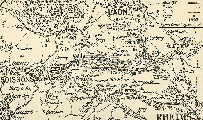
'Sketch Map of the Valley of the Aisne above Soissons', 1914, (c1920). Part of northern France, showing Laon and Rheims, at the start of the First World War. From "The Great World War - A History" Volume I, edited by Frank A Mumby. [The Gresham Publishing Company Ltd, London, c1920]
| px | px | dpi | = | cm | x | cm | = | MB |
Details
Creative#:
TOP24871320
Source:
達志影像
Authorization Type:
RM
Release Information:
須由TPG 完整授權
Model Release:
No
Property Release:
No
Right to Privacy:
No
Same folder images:
transporttransportationroadroadsrailwaysFrancebookrailwaylaneavenuewarrailwaylinelocationReimscenturyrailwaytrackstraintrackrailwaytrackfirstworldwarconceptpicardyWorldWarIWWIbattlefieldB/WWorldWarOnefrontline1910s20thcenturyChampagne-ArdenneThePrintCollector1stWorldWarAisneRheimsSoissonsTGNWW1LaonstreetmapfrontlineUnknownKeystoneArchivestheatreofwarTheGreatWorldWar:AHistoryFrankArthurMumbyMumbyFrankArthurGreshamPublishingCompanyGreshamPublishingCoLtd
1910s1st20thAAisneArchivesArthurArthurB/WChampagne-ArdenneCoCollectorCompanyFranceFrankFrankGreatGreshamGreshamHistoryIKeystoneLaonLtdMumbyMumbyOnePrintPublishingPublishingReimsRheimsSoissonsTGNTheTheUnknownWW1WWIWarWarWarWar:WorldWorldWorldWorldavenuebattlefieldbookcenturycenturyconceptfirstfrontfrontlinelanelinelinelocationmapofpicardyrailwayrailwayrailwayrailwayrailwaysroadroadsstreettheatretracktracktrackstraintransporttransportationwarwarwarworld
 Loading