
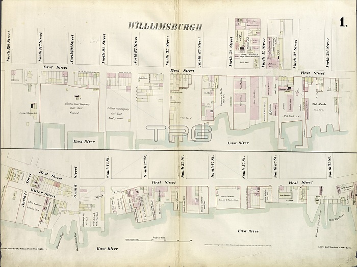
Plate 1: Map bounded by North 12th Street, 1st Street, North 5th Street, Wythe Street, North 3rd Street, 1st Street, South 7th Street, East River. 1855, William Perris, Brooklyn, New York, N. Y. , USA
| px | px | dpi | = | cm | x | cm | = | MB |
Details
Creative#:
TOP25191128
Source:
達志影像
Authorization Type:
RM
Release Information:
須由TPG 完整授權
Model Release:
No
Property Release:
No
Right to Privacy:
No
Same folder images:
112th18551st3rd5th7thagedamericaamericanbrooklyncartographiccartographydrawingdrawingseastgeographyhistorichistoricalhistoricallyhistoryillustrationillustrationsmapnewnorthnyofoldpaintedpaintingperrispicturepicturesplateplatesriverriversroadroadssouthStatesstreetstreetsU.S.AU.S.A.UnitedUSusavintagewaterwaterswilliamwytheyorkalimdiRM333D8FTS
112th18551st333D8FTS3rd5th7thRMStatesU.S.AU.S.A.USUnitedagedalimdiamericaamericanbrooklyncartographiccartographydrawingdrawingseastgeographyhistorichistoricalhistoricallyhistoryillustrationillustrationsmapnewnorthnyofoldpaintedpaintingperrispicturepicturesplateplatesriverriversroadroadssouthstreetstreetsusavintagewaterwaterswilliamwytheyork
 Loading