
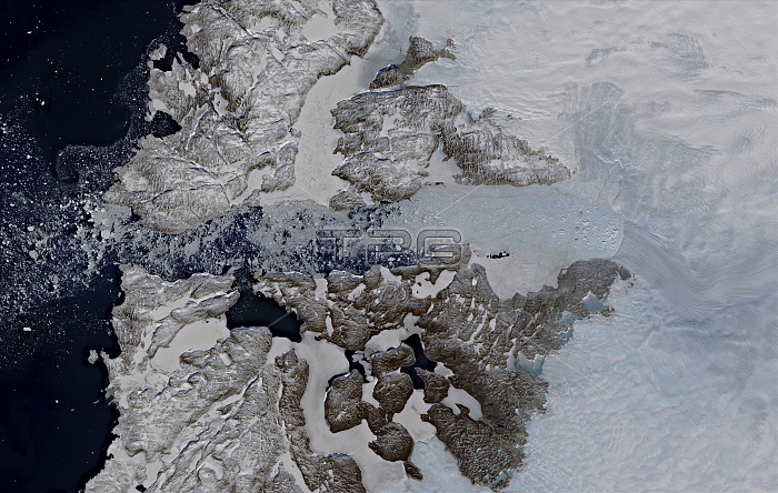
Jakobshavn Glacier in Greenland, satellite image. This glacier is one of the biggest sources of ice loss in Greenland, with the loss peaking in the period 2012-13. Between 2013 and 2017, the region drained by the glacier stopped shrinking in height and started to thicken. The Jakobshavn Glacier is now flowing more slowly, thickening, and advancing toward the ocean instead of retreating farther inland. Image data obtained on 29 April 2019, by the Copernicus Sentinel-2 satellites.
| px | px | dpi | = | cm | x | cm | = | MB |
Details
Creative#:
TOP25469185
Source:
達志影像
Authorization Type:
RM
Release Information:
須由TPG 完整授權
Model Release:
N/A
Property Release:
N/A
Right to Privacy:
No
Same folder images:
GEOGRAPHICALNO-ONENOBODYGREENLANDICGLACIALCLIMATECHANGEGLACIALRETREATGLACIALADVANCEGLOBALWARMINGCLIMATOLOGICALICELOSSICEGAINCOASTCOASTALGLACIERGREENLANDARCTICEARTHOBSERVATIONGEOGRAPHYGLACIOLOGYENVIRONMENTALSCIENCECLIMATOLOGYSATELLITEIMAGEFROMSPACECOPERNICUSSENTINEL-2SATELLITE21STCENTURY201929APRIL2019
292019201921STADVANCEAPRILARCTICCENTURYCHANGECLIMATECLIMATOLOGICALCLIMATOLOGYCOASTCOASTALCOPERNICUSEARTHENVIRONMENTALFROMGAINGEOGRAPHICALGEOGRAPHYGLACIALGLACIALGLACIALGLACIERGREENLANDGLACIOLOGYGLOBALGREENLANDICICEICEIMAGELOSSNO-ONENOBODYOBSERVATIONRETREATSATELLITESATELLITESCIENCESENTINEL-2SPACEWARMING
 Loading