
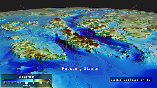
Recovery Glacier seabed topography, Antarctica. Topography of the seabed and land in the area of the Recovery Glacier, Antarctica. Elevation is colour-coded from maximum depths (dark blue) to highest elevations (red/brown). Recovery Glacier is about 111 kilometres long and 74 kilometres wide. It flows westward along Shackleton Ridge in East Antarctica. This image was created by the Antarctic BedMachine mapping project. BedMachine uses satellite data on ice flow motion to estimate what lies between ice thickness radar soundings. Understanding the underlying topography helps predict rates of ice loss and sea level rise associated with climate change.
| px | px | dpi | = | cm | x | cm | = | MB |
Details
Creative#:
TOP25731287
Source:
達志影像
Authorization Type:
RM
Release Information:
須由TPG 完整授權
Model Release:
N/A
Property Release:
N/A
Right to Privacy:
No
Same folder images:
 Loading