
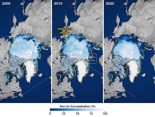
Satellite images showing the extent of the Arctic polar ice cap in July 2000, July 2010 and July 2020. The 1981-2010 median extent (yellow line) is shown on each map. The 2020 coverage is a record low for the time of year. Arctic sea ice (white) reaches a minimum in September, at the end of the Arctic summer. This minimal ice area is called the perennial ice cover. The perennial ice has been steadily decreasing since satellites began observing it in 1979, at a rate of about 10 percent per decade. This decrease is attributed to global warming. Data from microwave sensors on Defense Meteorological Satellite Program (DMSP) satellites.
| px | px | dpi | = | cm | x | cm | = | MB |
Details
Creative#:
TOP25967457
Source:
達志影像
Authorization Type:
RM
Release Information:
須由TPG 完整授權
Model Release:
N/A
Property Release:
N/A
Right to Privacy:
No
Same folder images:
 Loading