
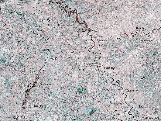
Radar satellite image of flooding (red) along the River Meuse (left) in the Netherlands and Belgium, and the River Rhine (centre right) and River Ruhr (top right) in Germany, on the 15th July 2021. This flooding resulted from more than a month's worth of rain falling in 24 hours. The flooding caused massive damage to buildings and infrastructure and the loss of at least 180 lives. Satellite data from the Copernicus Sentinel-1 satellite.
| px | px | dpi | = | cm | x | cm | = | MB |
Details
Creative#:
TOP26580431
Source:
達志影像
Authorization Type:
RM
Release Information:
須由TPG 完整授權
Model Release:
N/A
Property Release:
N/A
Right to Privacy:
No
Same folder images:
europeanwesterngermanyfloodslimburgprovincefloodsfloodplainfloodplainsrhineland-palatinatenorthrhine-westphaliaextremeweatherclimateemergencyclimatecrisisclimatechangeglobalwarmingweathereventstormcatastrophenaturaldisasterrainfallrain15thjuly202121stcentury2000s2020srivermeusenetherlandsbelgiumriverrhineriverruhrgermanybeligandutchhollandradarsatelliteimagerivernobodymeteorologytextlabellabelslabelledduisburgdusseldorfvenloroermondcologneleverkusenmapwesterneuropefloodedfromspaceno-onemeteorologicallabeledcopernicussentinel-1
15th2000s2020s202121stbelgiumbeligancatastrophecenturychangeclimateclimateclimatecolognecopernicuscrisisdisasterduisburgdusseldorfdutchemergencyeuropeeuropeaneventextremefloodedfloodplainfloodplainsfloodsfloodsfromgermanygermanyglobalhollandimagejulylabellabeledlabelledlabelsleverkusenlimburgmapmeteorologicalmeteorologymeusenaturalnetherlandsno-onenobodynorthprovinceradarrainrainfallrhinerhine-westphaliarhineland-palatinateriverriverriverriverroermondruhrsatellitesentinel-1spacestormtextvenlowarmingweatherweatherwesternwestern
 Loading