
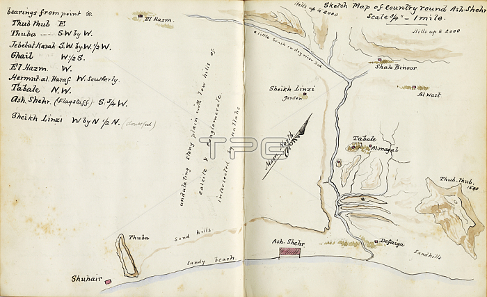
RGS424947 Sketch map of country around Ash Shihr, from \'Mokulla Hadramaut\', 1893 (pen & ink on paper) by Molesworth, Henry Bridges (b.1855); Royal Geographical Society, London, UK; (add.info.: Mokulla Hadramaut was the illustrated handwritten diary of Henry Bridges Molesworth;); 穢 Royal Geographical Society ; English, out of copyright.
| px | px | dpi | = | cm | x | cm | = | MB |
Details
Creative#:
TOP27056256
Source:
達志影像
Authorization Type:
RM
Release Information:
須由TPG 完整授權
Model Release:
No
Property Release:
No
Right to Privacy:
No
Same folder images:
coastcoastlineshorelineseamaritimecartographybookmiddleeastcoastlinemiddleeasternhand-drawnhandwritingannotatednotesnotebookhanddrawnash-shehrlabelledmappinggeographyyemenhadhramautDrawingMzdrawingbookmiddleeastcoastlinemiddleeasternhand-drawnhandwritingannotatednotesnotebookhanddrawnash-shehrlabelledmappinggeographycoastyemenhadhramaut
DrawingMzdrawingannotatedannotatedash-shehrash-shehrbookbookcartographycoastcoastcoastlinecoastlinecoastlinedrawndrawneasteasteasterneasterngeographygeographyhadhramauthadhramauthandhandhand-drawnhand-drawnhandwritinghandwritinglabelledlabelledmappingmappingmaritimemiddlemiddlemiddlemiddlenotebooknotebooknotesnotesseashorelineyemenyemen
 Loading