
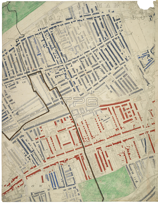
494915 Descriptive map of London Poverty, 1889 (hand-coloured litho) by English School, (19th century); Museum of London, UK; (add.info.: compiled and coloured by Charles Booth and assistants. this section covers Bow and Mile End. The colour coding ranges from black and dark blue to denote the poorest families to red for the well-to-do and yellow for the wealthy.); 穢 Museum of London ; English, out of copyright.
| px | px | dpi | = | cm | x | cm | = | MB |
Details
Creative#:
TOP27084380
Source:
達志影像
Authorization Type:
RM
Release Information:
須由TPG 完整授權
Model Release:
No
Property Release:
No
Right to Privacy:
No
Same folder images:
bowweaponweaponsstatisticStatisticsStatisticalanalysisurbaneastlondonpovertydividecoloursstatisticgraphaveragechartsocialvisualrepresentationeconomicfinancewealthdistributionstatisticseastendmileenddiscriminationaffluencecolourkeyhousingEngravingMzengravingeastlondonpovertydividecoloursstatisticgraphaveragechartsocialvisualrepresentationboweconomicfinancewealthdistributionstatisticseastendmileenddiscriminationaffluencecolourkeyhousing
EngravingMzengravingStatisticalStatisticsaffluenceaffluenceanalysisaverageaveragebowbowchartchartcolourcolourcolourscoloursdiscriminationdiscriminationdistributiondistributiondividedivideeasteasteasteasteconomiceconomicendendendendfinancefinancegraphgraphhousinghousingkeykeylondonlondonmilemilepovertypovertyrepresentationrepresentationsocialsocialstatisticstatisticstatisticstatisticsstatisticsurbanvisualvisualwealthwealthweaponweapons
 Loading