
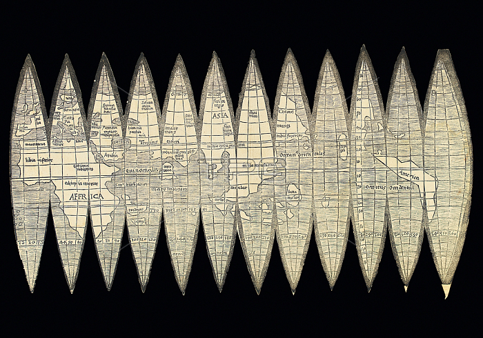
3482909 World map in the form of a set of terrestrial globe gores, 1507 (woodcut) by Waldseemuller, Martin (c.1470-c.1522); 18x34.4 cm; Private Collection; (add.info.: A set of 12 woodcut gores for a terrestrial globe with a diameter of 12cm (4翻 inches), overall maximum dimensions of the paper 180 x 344mm, trimmed to the margin of the gores. (Some light staining, two small clean tears in the joins between gores 10 and 11 and 11 and 12, traces of old folds along gore joins, old vertical paste mark at gore 6/7.) A SIGNIFICANT MILESTONE IN THE MAPPING OF THE WORLD. ONE OF FOUR KNOWN COPIES, THE ONLY SEPARATELY PUBLISHED MAP BY WALDSEEMuLLER IN PRIVATE HANDS. WALDSEEMuLLER\'S GLOBE MAP IS A MAP OF MANY FIRSTS: THE FIRST PRINTED GLOBE, THE FIRST \'ACCURATE AND COMPLETE\' MAP OF THE WORLD IN 360簞, THE FIRST MAP OR GLOBE TO NAME AMERICA, THE FIRST TO SHOW A SEPARATE SOUTH AND NORTH AMERICAN CONTINENT, THE FIRST TO SHOW THE PACIFIC OCEAN AS A SEPARATE ENTITY, THE FIRST TO SHOW CAPE HORN AND A DEFINED WESTERN COASTLINE TO SOUTH AMERICA. This globe map and Waldseemuller\'s large wall map (the only extant example now owned by the Library of Congress, U.S.A.), both first published in 1507, became the basis of all world maps and globes for the next 35 years. They presented a new revolutionary global geography, completing the fourth quadrant of the world. The globe map was drawn up by Martin Waldseemuller in St. Die, Lorraine, south west of Strasbourg. It was issued with the Universalis Cosmographia large wallmap, and a booklet, Cosmographiae Introductio, the three parts often described as the \'Birth Certificate of America\'.); Photo 穢 Christie\'s Images.
| px | px | dpi | = | cm | x | cm | = | MB |
Details
Creative#:
TOP27537813
Source:
達志影像
Authorization Type:
RM
Release Information:
須由TPG 完整授權
Model Release:
No
Property Release:
No
Right to Privacy:
No
Same folder images:
 Loading