
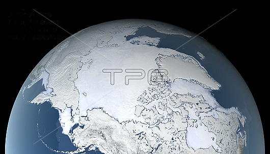
Arctic sea ice maximum, 25th February 2021, satellite image. The Arctic sea ice (white) reaches a maximum around late February-early March, at the end of the Arctic winter. This maximum extent for 2021 covered 14.88 million square kilometres. This is the third earliest maximum extent. The Arctic sea ice maximum extent has dropped by an average of 2.8 percent per decade since 1979. The sea ice data for this image is from the AMSR2 (Advanced Microwave Scanning Radiometer 2) sensor on the Japanese Shizuku satellite.
| px | px | dpi | = | cm | x | cm | = | MB |
Details
Creative#:
TOP27779102
Source:
達志影像
Authorization Type:
RM
Release Information:
須由TPG 完整授權
Model Release:
N/A
Property Release:
N/A
Right to Privacy:
No
Same folder images:
202021stcentury25february2020advancedmicrowavescanningradiometeradvancedmicrowavescanningradiometer2alaskaalaskanamsr2arcticarcticoceanclimatechangeclimatologicalclimatologycoldearthearthobservationenvironmenteosfromspacefrozenfrozenwatergeographicalgeographyglaciologyglobalwarminggreenlandicymapmaxmaximummicrowavemodelnorthamericanplanetrussiarussiansatellitesatelliteimageseaiceshizukusiberiasiberianspacewinter
2252020202021stadvancedadvancedalaskaalaskanamericanamsr2arcticarcticcenturychangeclimateclimatologicalclimatologycoldearthearthenvironmenteosfebruaryfromfrozenfrozengeographicalgeographyglaciologyglobalgreenlandiceicyimagemapmaxmaximummicrowavemicrowavemicrowavemodelnorthobservationoceanplanetradiometerradiometerrussiarussiansatellitesatellitescanningscanningseashizukusiberiasiberianspacespacewarmingwaterwinter
 Loading