
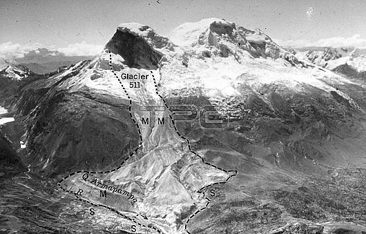
Aerial photograph showing the area overrun by the upper part of the debris avalanche from Peru's highest mountain Mount Huascaran. The avalanche, in the Ancash region of Peru, was caused by the 1970 Ancash earthquake. It was nearly 1 kilometre (km) wide, over 1.5km long and moved at over 160km per hour. The earthquake, also known as the Great Peruvian earthquake, struck 35 kilometres off the coast of Peru on the afternoon of the 31st May 1970. The earthquake had a magnitude of 7.9 and triggered a number of landslides, including the avalanche from Mount Huascaran. It was the worst natural disaster in Peru's history, causing widespread destruction and killing approximately 70,000 people and injuring a further 150,000.
| px | px | dpi | = | cm | x | cm | = | MB |
Details
Creative#:
TOP28966572
Source:
達志影像
Authorization Type:
RM
Release Information:
須由TPG 完整授權
Model Release:
n/a
Property Release:
n/a
Right to Privacy:
No
Same folder images:
 Loading