
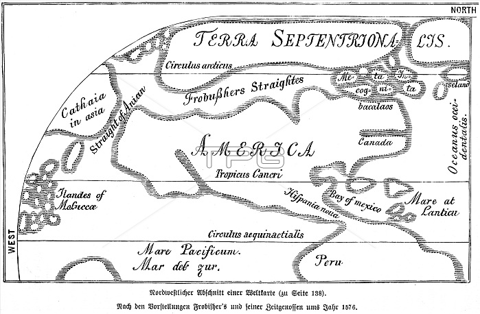
Map 1576, 16th century, Pacific, Mexico, Peru, Bay, Atlantic, Canada, America, Frobisher, equator, northern waterways, historical illustration 1885, Central America
| px | px | dpi | = | cm | x | cm | = | MB |
Details
Creative#:
TOP29236730
Source:
達志影像
Authorization Type:
RM
Release Information:
須由TPG 完整授權
Model Release:
No
Property Release:
No
Right to Privacy:
No
Same folder images:
16thc.16thcenturyAmericaAtlanticOceansAtlanticOceanAtlanticbaysbaycalaCanadaCanadiancanalchannelcoastalareascoastalareacoastalregioncoastscoastcovedesertedemptyequatorgeographyHistoricalillustrationhistoricalHistoricillustrationsHistoricillustrationhistoricillustrationsillustrationLatinAmericamapsmapmexicanMexiconobodynooneNoPeopleNorthAmericanorthernoceansoceanPacificOceanPacificPeruvianPeruseashoreSilentoceansixteenthcenturySouthAmericanSouthAmericathe1500stravelphotographyuninhabitedwatercanalwaterfrontwaterwayswaterway
1500s16th16thAmericaAmericaAmericaAmericaAmericanAtlanticAtlanticAtlanticCanadaCanadianHistoricHistoricHistoricalLatinMexicoNoNorthOceanOceanOceansPacificPacificPeoplePeruPeruvianSilentSouthSouthareaareasbaybaysc.calacanalcanalcenturycenturychannelcoastcoastalcoastalcoastalcoastscovedesertedemptyequatorgeographyhistorichistoricalillustrationillustrationillustrationillustrationsillustrationsmapmapsmexicannonobodynorthernoceanoceanoceansonephotographyregionseashoresixteenththetraveluninhabitedwaterwaterfrontwaterwaywaterways
 Loading