
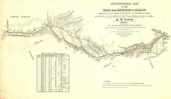
Topographical map of the road from Missouri to Oregon, commencing at the mouth of the Kansas in the Missouri River and ending at the mouth of the Walla-Wallah in the Columbia, 1846. Produced in 1846 in seven sections, it was compiled by order of the U.S. Senate from the field notes and journal of Captain John C. Fre?mont (1813-90) and associated sketches and notes of his assistant, Charles Preuss (1803-54). It traces the route to the Pacific paralleling the large river systems traversing the North American continent. Fre?mont was an experienced frontiersman who led four expeditions into the western regions of the United States. Popularly known in his day as "The Pathfinder," Fre?mont worked with the frontiersman Kit Carson and made large contributions to early knowledge about the geography of the American West. Each section of the map shows in great detail the initial route that Fre?mont took on his second expedition, in 1843-44, along the Kansas, Platte, Snake, and Walla Walla Rivers and parts of the Oregon Trail. The scale is 10 miles to the inch (16.09 kilometers to 2.54 centimeters).
| px | px | dpi | = | cm | x | cm | = | MB |
Details
Creative#:
TOP29694897
Source:
達志影像
Authorization Type:
RM
Release Information:
須由TPG 完整授權
Model Release:
Not Required
Property Release:
Not Required
Right to Privacy:
No
Same folder images:
 Loading