
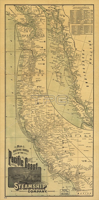
Map showing routes of the Pacific coast Steamship Company, 1891. This foldable tourist brochure, published by Rand McNally and Company in 1891, shows the main routes and schedules of the Pacific Coast Steamship Company. One side of the large sheet is a map showing the companys routes from San Diego, Los Angeles, San Francisco, Seattle, and other ports. An inset map on the right shows the routes from Seattle and Victoria, British Columbia, through the Inside Passage to Juneau, Sitka, and Glacier Bay in Alaska. A table in the upper right gives distances in nautical miles from San Francisco to a large number of ports, including inland ports on the Columbia River. Railroads also are shown. The reverse side gives detailed travel information, including lists of agents, scheduled rates, and descriptions of the sites to be seen on the different excursions offered by the company, including the Eureka (Humboldt Bay) Route, the Portland and Astoria (Oregon) Route, the Alaska Route, the California Southern Coast Route, and others.
| px | px | dpi | = | cm | x | cm | = | MB |
Details
Creative#:
TOP29694953
Source:
達志影像
Authorization Type:
RM
Release Information:
須由TPG 完整授權
Model Release:
Not Required
Property Release:
Not Required
Right to Privacy:
No
Same folder images:
 Loading