
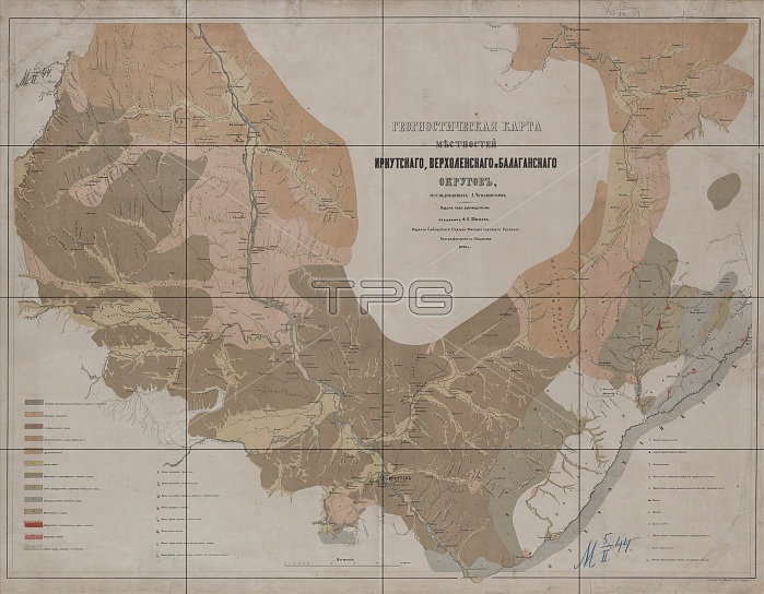
Geognostic Map of the Localities of Irkutsk, Verkholensk, and Balagansk Districts, 1873. The first geological (geognostic) maps in Russia were produced in the 1850s. This map of the Irkutsk region was published by the Siberian Department of the Imperial Russian Geographic Society under the leadership of Academician F.B. Schmidt. It shows the location of mines and minerals, caves, gaps, salt deposits, springs, landslides, and patterns of freezing on Lake Baikal. The colors denote different types of rock.
| px | px | dpi | = | cm | x | cm | = | MB |
Details
Creative#:
TOP29694996
Source:
達志影像
Authorization Type:
RM
Release Information:
須由TPG 完整授權
Model Release:
Not Required
Property Release:
Not Required
Right to Privacy:
No
Same folder images:
libraryhistoricalcavemapindustrycountrylakesciencegeologygeologicalspringgeographycolorindustrialminingcaveslocationcenturymineralmineralsminesmineRussiaRussiancartographysaltconceptlegendSiberiaLibraryofCongressrussianfederationLakeBaikalColour19thcenturyCyrillic1870slandslidenineteenthcenturyIrkutskhistoryhistoricgeographicalfeaturemap-makingRossiyaTGNmapMapmakingRussianStateLibraryCongressionalLibrarybaikalHeritageArt19th-centurycartographicMeetingofFrontiersriftlakeSiberianBranchoftheRussianGeographicSociety
1870s19th19th-centuryArtBaikalBranchColourCongressCongressionalCyrillicFrontiersGeographicHeritageIrkutskLakeLibraryLibraryLibraryMapmakingMeetingRossiyaRussiaRussianRussianRussianSiberiaSiberianSocietyStateTGNbaikalcartographiccartographycavecavescenturycenturycenturycolorconceptcountryfeaturefederationgeographicalgeographygeologicalgeologyhistorichistoricalhistoryindustrialindustrylakelakelandslidelegendlibrarylocationmapmapmap-makingminemineralmineralsminesminingnineteenthofofofriftrussiansaltsciencespringthe
 Loading