
filter
-
Brand
- By Category
- Direction
- Date Range
79Events
Pictures
Events

Editorial EXCLUSIVE: Photographer discovers abandoned ?time capsule? villa untouched for 100 years
- 2023-10-04
- 10

Editorial `Valley` Skyscraper Displays Remarkable Cantilevered Design
- 2022-09-21
- 6

Editorial The Titan's Goblet.
- 2020-03-02
- 1

Editorial Profile Aare, Illustration of the geological profile Pfaffenkopf - M?nnlistock - Benzlauistock from the 19th century, plate VI, after p. 378, 1830, Franz Joseph Hugi: Naturhistorische Alpenreise: vorgelesen der Naturforschenden Gesellschaft in Solothur...
- 2020-01-15
- 1
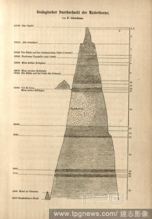
Editorial Geological section of the Matterhorn with altitude information and markings of the camps Whympers, Tyndall's rope, huts and hotels, wood engraving, to p. 524.
- 2020-01-15
- 1

Editorial Profile Urbach saddle, Illustration of the geological profile Mattenberg - Urbach saddle from the 19th century, plate III, after p. 378, 1830, Franz Joseph Hugi: Naturhistorische Alpenreise: vorgelesen der Naturforschenden Gesellschaft in Solothurn. So...
- 2020-01-15
- 1
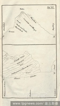
Editorial Titlis - Aletsch-Gletscher, Illustration of the geological profiles of Titlis and Aletsch Glacier from the 19th century, pl. XI, after p. 378, 1830, Franz Joseph Hugi: Naturhistorische Alpenreise: vorgelesen der Naturforschenden Gesellschaft in Solothu...
- 2020-01-15
- 1

Editorial Profile Urbach-Thal, Illustration of the geological profile Laubstock - Tristenhorn from the 19th century, plate V, after p. 378, 1830, Franz Joseph Hugi: Naturhistorische Alpenreise: vorgelesen der Naturforschenden Gesellschaft in Solothurn. Solothurn...
- 2020-01-15
- 1
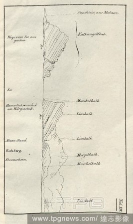
Editorial Profil Rigi - Stanserhorn, Illustration of the geological profile from the Rigi to the Stanserhorn from the 19th century, pl. XIV, after p. 378, 1830, Franz Joseph Hugi: Naturhistorische Alpenreise: vorgelesen der Naturforschenden Gesellschaft in Solot...
- 2020-01-15
- 1
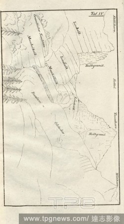
Editorial Profile Rosenlauigletscher, Illustration of the geological profile of the 19th century Rosenlaui Glacier, plate IV, after p. 378, 1830, Franz Joseph Hugi: Naturhistorische Alpenreise: vorgelesen der Naturforschenden Gesellschaft in Solothurn. Solothurn...
- 2020-01-15
- 1

Editorial B?tzberg im Urserntal - Kalkthal am Susten, Illustration of the geological profiles B?tzberg in the Urserental and Kalkthal at Susten from the 19th century, plate X, after p. 378, 1830, Franz Joseph Hugi: Naturhistorische Alpenreise: vorgelesen der Nat...
- 2020-01-15
- 1

Editorial Profile Urbachthal, Illustration of the geological profile Tosenhorn - Engelstock from the 19th century, plate VII, after p. 378, 1830, Franz Joseph Hugi: Naturhistorische Alpenreise: vorgelesen der Naturforschenden Gesellschaft in Solothurn. Solothurn...
- 2020-01-15
- 1
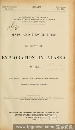
Editorial Maps and descriptions of routes of exploration in Alaska in 1898 : with general information concerning the territory : Geological Survey (U.S.).
- 2020-01-15
- 1
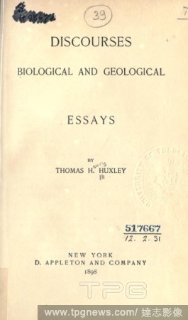
Editorial Discourses biological and geological; essays by Thomas H. Huxley : Huxley, Thomas Henry, 1825-1895.
- 2019-12-19
- 1
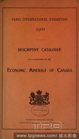
Editorial Descriptive catalogue of a collection of the economic minerals of Canada : Geological Survey of Canada.
- 2019-12-18
- 1
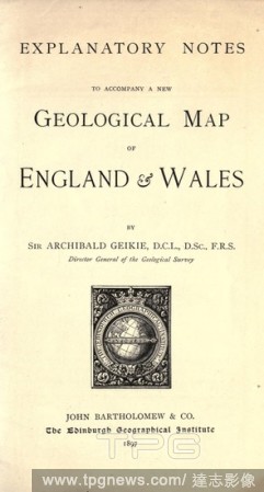
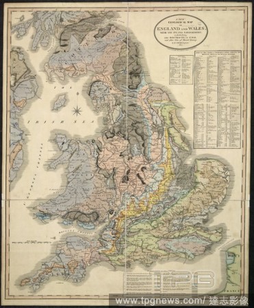
Editorial Explanatory notes to accompany a new geological map of England and Wales : Geikie, Archibald, Sir, 1835-1924.
- 2019-12-18
- 1
Editorial Report on forests : Geological Survey of New Jersey.
- 2019-12-18
- 1

Editorial Worldview leads to True Faith Title page for Bernard Nieuwentyt, The right use of the world views demonstrated for the conviction of ungodists and unbelievers, 1727 Right use of world reflections (title on object), On a pedestal the female personificat...
- 2019-12-18
- 1
Editorial Reminiscences among the rocks in connection with the Geological survey of Canada : Weston, Thomas Chesmer, 1832-1911.
- 2019-12-18
- 1

Editorial Reminiscences among the rocks : in connection with the Geological Survey of Canada : Weston, Thomas Chesmer, b. 1832-.
- 2019-12-18
- 1
Editorial Table for interconversion of miles and logarithms of meters, for distances from 10 to 100 miles [microform] : Geological Survey (U.S.).
- 2019-12-18
- 1
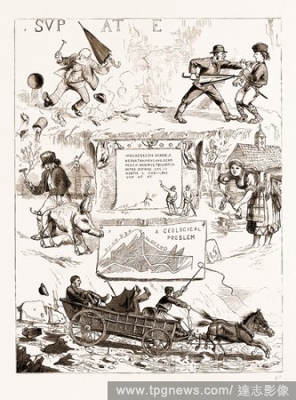
Editorial SCENES ALONG THE DANUBE, IRON GATES DISTRICT, 1883: 1. Under Trajan's Tablet: The Vandal Fisherman and the Avenging Antiquarian. 2. A Serbian Legend: Peasants Using Hog's Bristles as Nails. 3. Trajan's Tablet on the Danube Opposite the Austrian Village...
- 2019-12-17
- 1
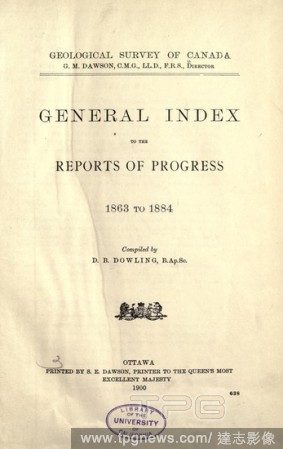
Editorial General index to the Reports of progress, 1863 to 1884 : Geological Survey of Canada.
- 2019-11-19
- 1
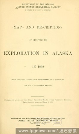
Editorial Maps and descriptions of routes of exploration in Alaska in 1898, with general information concerning the territory (Ten maps in accompanying envelope) ... : Geological Survey (U.S.).
- 2019-11-19
- 1
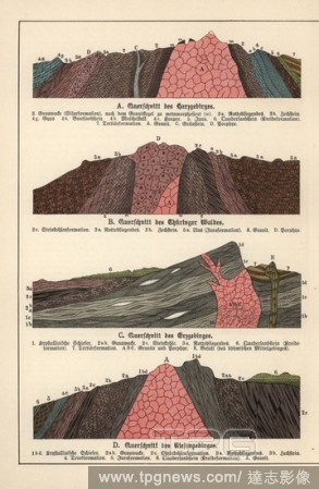
Editorial Geological cross-sections of the Harz Mountains, Thuringian Forest, Ore Mountains and Riesenge Mountains. Chromolithograph from Dr. Fr. Rolle's "Geology and Paleontology" section in Gotthilf Heinrich von Schubert's "Naturgeschichte," Schreiber, Munich,...
- 2019-11-19
- 1
Editorial View of a Colliery at the Edge of a Town.
- 2019-11-18
- 1
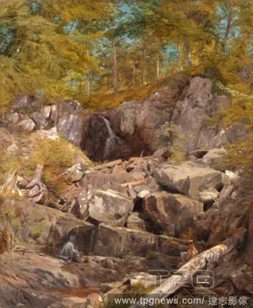
Editorial A Study of Trap Rock (Buttermilk Falls).
- 2019-06-21
- 1
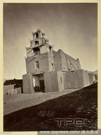
Editorial The Church of San Miguel, the Oldest in Santa Fe, N.M. Timothy O'Sullivan; American, born Ireland, 1840-1882. Date: 1873. Dimensions: 27.7 x 20.2 cm (image/page); 49.7 x 38.3 cm (album page). Albumen print, from the album "Geographical & Geological Exp...
- 2019-04-01
- 1
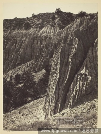
Editorial Rain Sculpture, Salt Creek Ca?on, Utah. William H. Bell; American, 1830-1910. Date: 1872. Dimensions: 27.6 x 20.4 cm (image/paper); 50.4 x 40.6 cm (album page). Albumen print, from the album "Geographical & Geological Explorations & Surveys West of the...
- 2019-04-01
- 1

Editorial Aboriginal Life Among the Navajoe Indians, Near Old Fort Defiance, N.M. Timothy O'Sullivan; American, born Ireland, 1840-1882. Date: 1873. Dimensions: 27.5 x 20.2 cm (image/paper); 49.9 x 39.4 cm (mount). Albumen print, from the album "Geographical & G...
- 2019-04-01
- 1

Editorial The Church of San Miguel, the Oldest in Santa Fe, N.M. Timothy O'Sullivan; American, born Ireland, 1840-1882. Date: 1873. Dimensions: 27.7 x 20.2 cm (image/page); 49.7 x 38.3 cm (album page). Albumen print, from the album "Geographical & Geological Exp...
- 2019-03-18
- 1

Editorial Rain Sculpture, Salt Creek Ca?on, Utah. William H. Bell; American, 1830-1910. Date: 1872. Dimensions: 27.6 x 20.4 cm (image/paper); 50.4 x 40.6 cm (album page). Albumen print, from the album "Geographical & Geological Explorations & Surveys West of the...
- 2019-03-18
- 2
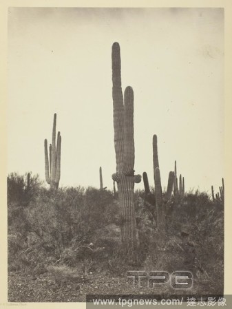
Editorial Cereus Giganteus, Arizona. Timothy O'Sullivan; American, born Ireland, 1840-1882. Date: 1871. Dimensions: 27.4 x 20.1 cm (image/paper); 49.8 x 38.2 cm (album page). Albumen print, from the album "Geographical & Geological Explorations & Surveys West of...
- 2019-03-18
- 1
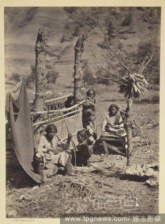
Editorial Aboriginal Life Among the Navajoe Indians, Near Old Fort Defiance, N.M. Timothy O'Sullivan; American, born Ireland, 1840-1882. Date: 1873. Dimensions: 27.5 x 20.2 cm (image/paper); 49.9 x 39.4 cm (mount). Albumen print, from the album "Geographical & G...
- 2019-03-18
- 2
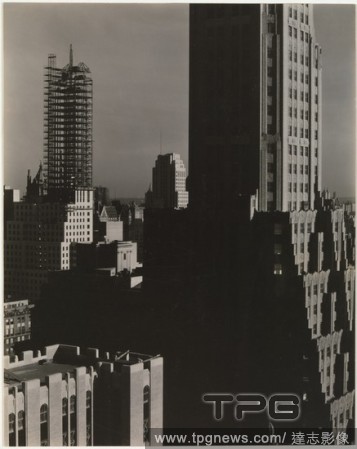
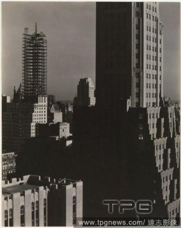
Editorial From My Window at the Shelton, North.
- 2019-03-06
- 1

Editorial View of a Colliery at the Edge of a Town.
- 2019-02-22
- 1

Editorial From My Window at the Shelton, North.
- 2019-02-11
- 1

Editorial The Titan's Goblet.
- 2019-02-01
- 1

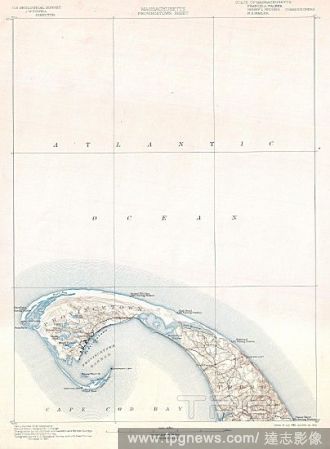
Editorial 1900, U.S. Geological Survey Map of Provincetown, Cape Cod, Massachusetts.
- 2019-01-23
- 1

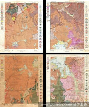
Editorial 1896, U.S. Geological Survey Geological Map of Yellowstone National Park, 4 sheets.
- 2019-01-23
- 1
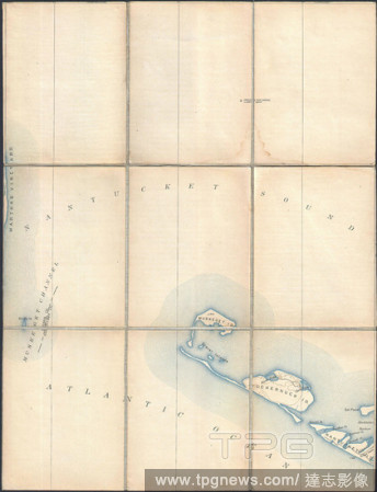
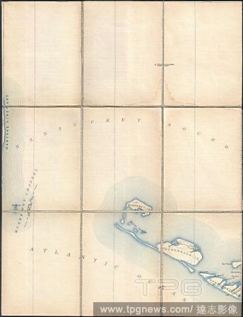
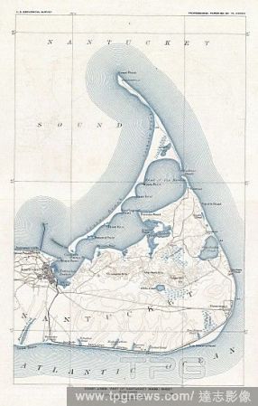
Editorial 1887, Pocket Map Version of the U.S. Geological Survey Map of western Nantucket, Massachusetts.
- 2019-01-23
- 1
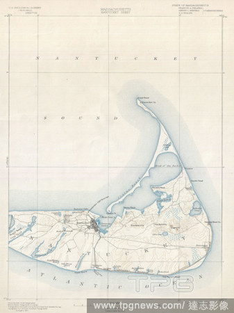
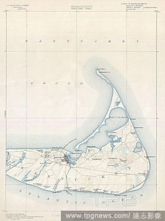
Editorial 1898, U.S. Geological Survey Map of Nantucket, Massachusetts.
- 2019-01-23
- 1
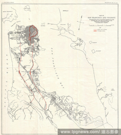
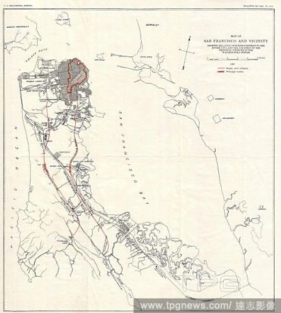
Editorial 1907, Geological Survey Map of San Francisco Peninsula after 1906 Earthquake.
- 2019-01-23
- 1

Editorial 1900, U.S. Geological Survey of Boston Bay, Massachusetts.
- 2019-01-23
- 1

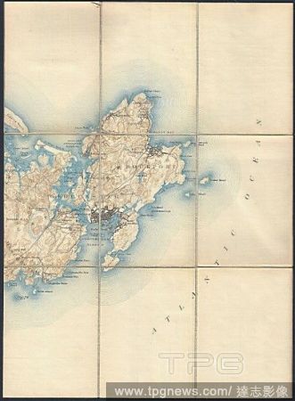
Editorial 1898, U.S. Geological Survey Map of Gay Head, Marthas Vineyard, Massachusetts.
- 2019-01-23
- 1
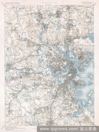
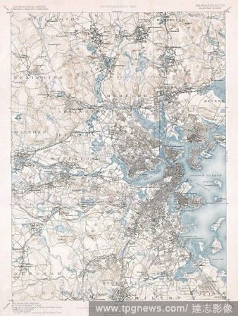
Editorial 1900, U.S. Geological Survey of Boston and Vicinity, Massachusetts.
- 2019-01-23
- 1
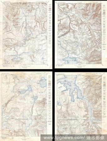
Editorial 1896, U.S. Geological Survey Map of Yellowstone National Park, 4 sheets.
- 2019-01-23
- 1

Editorial 1887, Pocket Map Version of the U.S. Geological Survey Map of Gloucester and Rockport, Massachusetts.
- 2019-01-23
- 1
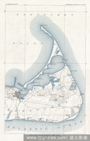
Editorial 1919, U.S. Geological Survey Map of Nantucket, Massachusetts.
- 2019-01-23
- 1
Editorial New Geological map. A New Geological Map of England and Wales ... London : J. Cary, 1820. Source: Maps.1180.(1),. Language: English.
- 2018-12-06
- 1
Editorial First Geological map. A delineation of the Strata of England and Wales,. London; J. Cary; 1815. Source: Maps.K.Top.5.76.6.TAB,. Language: English.
- 2018-12-06
- 1

Editorial A coloured geological map of England and Wales. A Physical and Geological Map of England & Wales. By G.B. Greenough ... (on the basis of the original Map by W. Smith, 1815). Revised and improved under the superintendence of a Committee of the Geologica...
- 2018-12-06
- 1
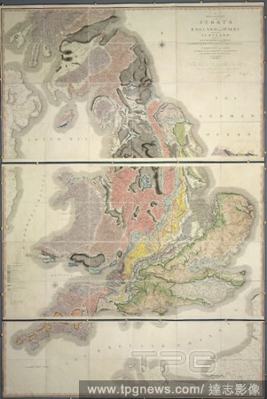
Editorial William Smith's geological map of 1815, called A Delineation of the Strata of England and Wales, with part of Scotland. It was the first geological map of this type. A delineation of the Strata of England and Wales, with part of Scotland; exhibiting t...
- 2018-12-06
- 1

Editorial Barbados. Geological Map of Barbados. London, 1890. Source: Maps.20.a.32. Language: English.
- 2018-12-06
- 1
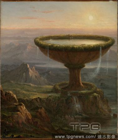
Editorial The Titan's Goblet.
- 2018-08-09
- 1

Editorial View of a Colliery at the Edge of a Town.
- 2018-08-08
- 1
Editorial From My Window at the Shelton, North.
- 2018-08-06
- 1

Editorial A Study of Trap Rock (Buttermilk Falls).
- 2018-08-06
- 1
Editorial 1900, U.S. Geological Survey Map of Provincetown, Cape Cod, Massachusetts.
- 2018-08-06
- 1
Editorial 1896, U.S. Geological Survey Geological Map of Yellowstone National Park, 4 sheets.
- 2018-08-06
- 1
Editorial 1887, Pocket Map Version of the U.S. Geological Survey Map of western Nantucket, Massachusetts.
- 2018-08-06
- 1
Editorial 1898, U.S. Geological Survey Map of Nantucket, Massachusetts.
- 2018-08-03
- 1
Editorial 1907, Geological Survey Map of San Francisco Peninsula after 1906 Earthquake.
- 2018-08-03
- 1

Editorial 1900, U.S. Geological Survey of Boston Bay, Massachusetts.
- 2018-08-03
- 1

Editorial 1898, U.S. Geological Survey Map of Gay Head, Marthas Vineyard, Massachusetts.
- 2018-08-03
- 1
Editorial 1900, U.S. Geological Survey of Boston and Vicinity, Massachusetts.
- 2018-08-03
- 1

Editorial 1896, U.S. Geological Survey Map of Yellowstone National Park, 4 sheets.
- 2018-08-03
- 1
Editorial 1887, Pocket Map Version of the U.S. Geological Survey Map of Gloucester and Rockport, Massachusetts.
- 2018-08-03
- 1
Editorial 1919, U.S. Geological Survey Map of Nantucket, Massachusetts.
- 2018-08-03
- 1
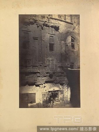
Editorial The Theater of Marcellus, from the Piazza Montanara, by 1858, Albumen silver print from glass negative, Image: 41.9 x 27.4 cm (16 1/2 x 10 13/16 in.), Photographs, Robert Macpherson (British, Tayside, Scotland 1811?1872 Rome), Like geological strata la...
- 2018-08-03
- 1
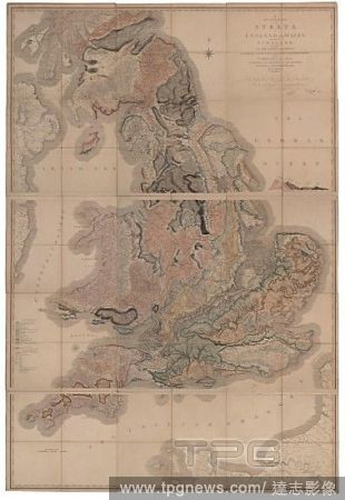
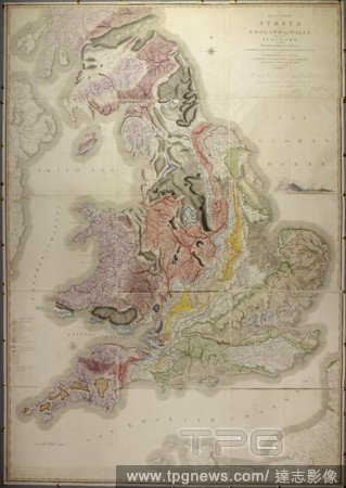
Editorial Delineation of the Strata of England and Wales with a Part of Scotland (The first geological map of Britain).
- 2018-08-02
- 1
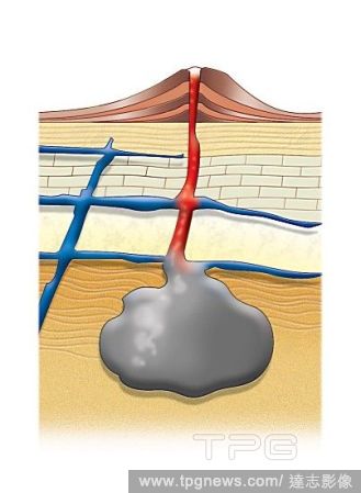
Editorial Geological intrusion - concordant and discordant plutons.
- 2018-07-31
- 2
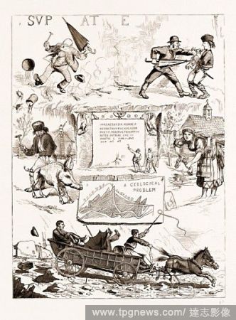
Editorial SCENES ALONG THE DANUBE, IRON GATES DISTRICT, 1883: 1. Under Trajan's Tablet: The Vandal Fisherman and the Avenging Antiquarian. 2. A Serbian Legend: Peasants Using Hog's Bristles as Nails. 3. Trajan's Tablet on the Danube Opposite the Austrian Village...
- 2018-07-27
- 1
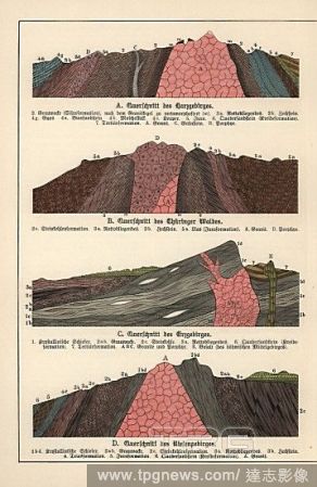
Editorial Geological cross-sections of the Harz Mountains, Thuringian Forest, Ore Mountains and Riesenge Mountains. Chromolithograph from Dr. Fr. Rolle's "Geology and Paleontology" section in Gotthilf Heinrich von Schubert's "Naturgeschichte," Schreiber, Munich,...
- 2018-07-26
- 1
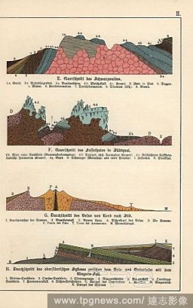
Editorial Geological cross-sections of the Black Forest, South Tyrol, mount Vesuvius and the Niagara Falls. Chromolithograph from Dr. Fr. Rolle's "Geology and Paleontology" section in Gotthilf Heinrich von Schubert's "Naturgeschichte," Schreiber, Munich, 1886.
- 2018-07-26
- 1

Editorial Plan of a coal mine and mode of ventilation, 19th century. Geological sections of metallic veins, chalk, basalt, and limestone. Copperplate engraving by Wilson Lowry from Abraham Rees' Cyclopedia or Universal Dictionary of Arts, Sciences and Literature...
- 2018-07-25
- 1
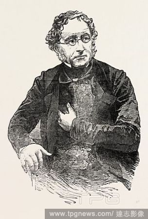
Editorial SIR HENRY THOMAS DE LA BECHE, C.D., F.R.S., F.G.S., F.L.S.; English geologist and palaeontologist who helped pioneer early geological survey methods, 1851 engraving.
- 2018-07-25
- 1

Editorial A MAP SHOWING THE GEOLOGICAL POSITION AND COMMERCIAL DISTRIBUTION OF COAL IN ENGLAND AND WALES.
- 2018-07-24
- 1
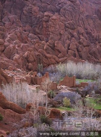
Editorial The village of Tamlalt with its strange geological formations, called " doigts de singes" -monkey fingers. Dades Valley.
- 2018-06-26
- 1
 Loading