
filter
-
Brand
- By Category
- Direction
- Date Range
65Events
Pictures
Events
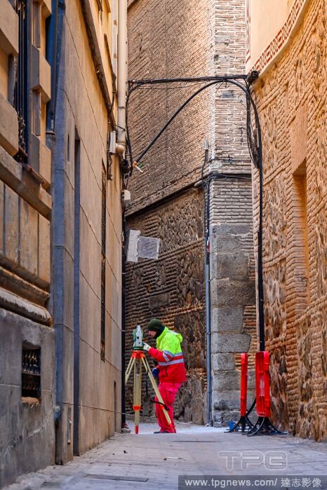
Editorial Architecture in Toledo, Spain - 09 Feb 2023
- 2023-12-10
- 1
Editorial Architecture in Toledo, Spain - 09 Feb 2023
- 2023-12-07
- 1
Editorial Architecture in Toledo, Spain - 09 Feb 2023
- 2023-12-07
- 1
Editorial Architecture in Toledo, Spain - 09 Feb 2023
- 2023-11-14
- 1
Editorial Architecture in Toledo, Spain - 09 Feb 2023
- 2023-11-01
- 1

Editorial Architecture in Toledo, Spain - 09 Feb 2023
- 2023-11-01
- 1
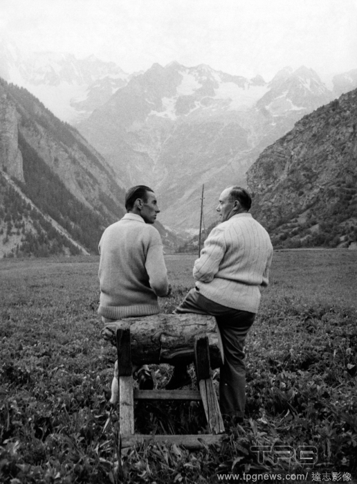
Editorial Pietro Alaria with Ubaldo Rey
- 2023-10-30
- 2
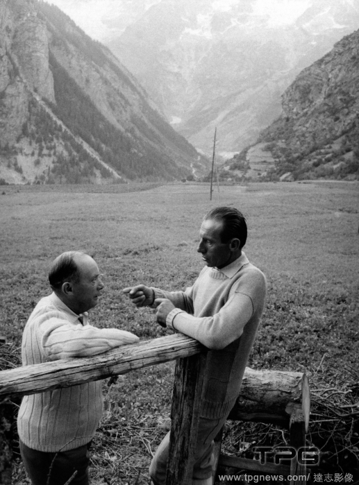
Editorial Pietro Alaria with Ubaldo Rey
- 2023-10-29
- 1

Editorial The memoirist Saïd Sayrafiezadeh with a copy of “The Measure of Manhattan,” a biography of the surveyor John Randel Jr. published by Norton, at the centenary celebration of W.W. Norton & Company, the oldest and largest independently owned publishing house in the country, at Cipriani in New York, June 7, 2023. (Jutharat Pinyodoonyachet/The New York Times)
- 2023-06-19
- 1

Editorial The memoirist Saïd Sayrafiezadeh with a copy of “The Measure of Manhattan,” a biography of the surveyor John Randel Jr. published by Norton, at the centenary celebration of W.W. Norton & Company, the oldest and largest independently owned publishing house in the country, at Cipriani in New York, June 7, 2023. (Jutharat Pinyodoonyachet/The New York Times)
- 2023-06-15
- 1

Editorial The memoirist Saïd Sayrafiezadeh with a copy of “The Measure of Manhattan,” a biography of the surveyor John Randel Jr. published by Norton, at the centenary celebration of W.W. Norton & Company, the oldest and largest independently owned publishing house in the country, at Cipriani in New York, June 7, 2023. (Jutharat Pinyodoonyachet/The New York Times)
- 2023-06-07
- 1

Editorial The memoirist Saïd Sayrafiezadeh with a copy of “The Measure of Manhattan,” a biography of the surveyor John Randel Jr. published by Norton, at the centenary celebration of W.W. Norton & Company, the oldest and largest independently owned publishing house in the country, at Cipriani in New York, June 7, 2023. (Jutharat Pinyodoonyachet/The New York Times)
- 2023-05-01
- 1

Editorial A plan of part of the coast of East Florida. A PLAN of Part of the Coast of EAST FLORIDA including S.t John's River from an actual Survey BY W.m Gerard De Brahm Esq.r SURVEYOR GENERAL of the Southern District of NORTH AMERICA. [London] : 1769, done by ...
- 2022-12-24
- 1
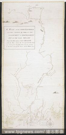
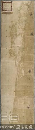
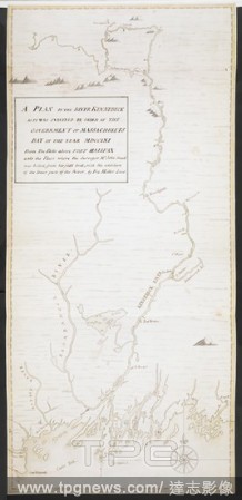
Editorial A plan of the River Kennebeck as it was surveyed by order of the Government of Massachusets Bay in the year MDCCLXI from the falls above Halifax unto the place where the surveyor John Small was killed, from his field book, with the addition of lower pa...
- 2022-12-24
- 1
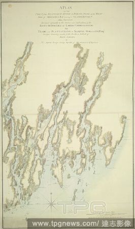
Editorial A plan of the coast from Kennebeck River to Round Pond. A PLAN OF THE COAST from KENNEBECK RIVER to ROUND POND on the WEST SIDE of MUSCONGUS BAY, including the ISLANDS, RIVERS, &c. within that Extent / Surveyed agreeably to the Orders and Instructions ...
- 2022-12-24
- 1

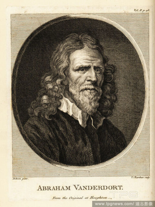
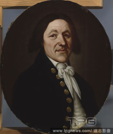
Editorial Abraham van der Doort (1575/1580-1640). Dutch artist, Surveyor of the Pictures of King Charles I. Portrait by William Dobson (1611-1646), late 1630s. The State Hermitage Museum. Saint Petersburg. Russia.
- 2022-12-24
- 1

Editorial NASA Will Launch Bizarre `Inflatable Heat Shield` Into Space Next Month - And It Could Help Humans Land Safely On Mars One Day
- 2022-10-17
- 1

Editorial Newspaper "Pravda" printing works
- 2022-09-09
- 1

Editorial EXCLUSIVE: POOPING THE QUESTION!
- 2022-07-22
- 7
Editorial A map to illustrate a report upon the Bhaugiruthee River. Map to illustrate a report upon the Bhaugiruthee River, by Capt? W. S. Sherwill ... Scale, 16 miles to an inch. Calcutta : Surveyor General's Office, 1857. Source: Maps 53580.(27.). Language: ...
- 2022-04-25
- 1

Editorial Pictured Connor Tierney who is fighting for the world bareknuckle boxing title in New York.
- 2022-03-11
- 1

Editorial A plan of the River Kennebeck as it was surveyed by order of the Government of Massachusets Bay in the year MDCCLXI from the falls above Halifax unto the place where the surveyor John Small was killed, from his field book, with the addition of lower pa...
- 2022-01-18
- 1

Editorial A plan of the coast from Kennebeck River to Round Pond. A PLAN OF THE COAST from KENNEBECK RIVER to ROUND POND on the WEST SIDE of MUSCONGUS BAY, including the ISLANDS, RIVERS, &c. within that Extent / Surveyed agreeably to the Orders and Instructions ...
- 2022-01-18
- 1

Editorial Portrait of William Westley, 1750-1800 James Millar, Surveyor, made maps of Birmingham charting its growth in 18th Century, Book, Oil Painting, Portrait, Male, Clothing, Coat.
- 2022-01-18
- 1
Editorial A plan of part of the coast of East Florida. A PLAN of Part of the Coast of EAST FLORIDA including S.t John's River from an actual Survey BY W.m Gerard De Brahm Esq.r SURVEYOR GENERAL of the Southern District of NORTH AMERICA. [London] : 1769, done by ...
- 2022-01-18
- 1

Editorial Sir Benjamin Rudgerd, surveyor.
- 2022-01-18
- 1

Editorial Friar Antonio de Villacast?n (1512-1603). Spanish religious of the Order of Saint Jerome and quantity surveyor. Director of the works of the Monastery of El Escorial. Portrait. Illustration by Llanta. Lithography. Cr?nica General de Espa?a, Historia Il...
- 2021-06-04
- 1
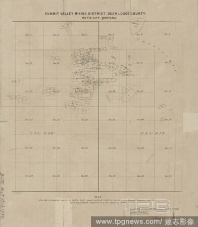
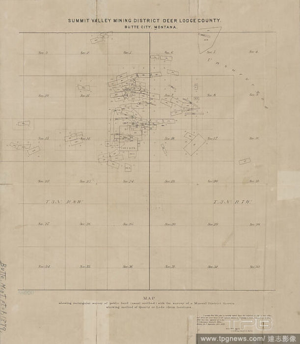
Editorial Summit Valley Mining District, Deer Lodge County, Butte City, Montana , cartographic, Maps, 1879, Mason, Roswell H., Donaldson, Thomas, 1843-1898, United States. Surveyor General of Montana.
- 2021-04-07
- 1
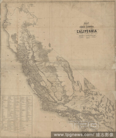
Editorial Map of public surveys in California , cartographic, Maps, 1861, United States. Surveyor General, Beale, Edward Fitzgerald, 1822-1893, Bien, Julius, 1826-1909.
- 2021-04-07
- 1
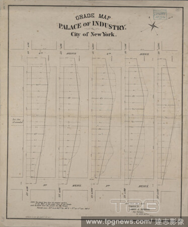
Editorial Grade map, Palace of Industry : City of New York / compiled by James E. Serrell, City Surveyor, New York, Feb'y 1871., cartographic, Maps, 1871, Serrell, James E.
- 2021-02-22
- 2

Editorial Portrait of William Westley, 1750-1800 James Millar, Surveyor, made maps of Birmingham charting its growth in 18th Century, Book, Oil Painting, Portrait, Male, Clothing, Coat.
- 2021-02-21
- 1
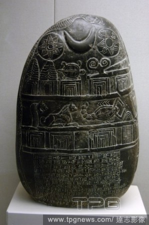
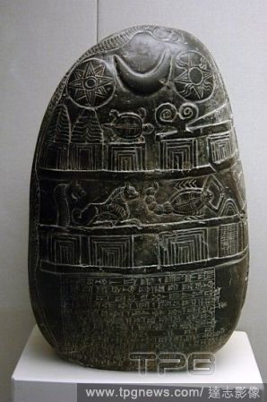
Editorial Mesopotamian Art. Kassite Dynasty. The Eanna-shum-iddina kudurru (1125-1100 B.C.). It describes the land grant made by Governor Eanna-shum-iddina to Gula-Eresh witnessed by his surveyor Amurru-Bel-Zeri. The bottom is inscribed in cuneiform script and ...
- 2020-12-01
- 1

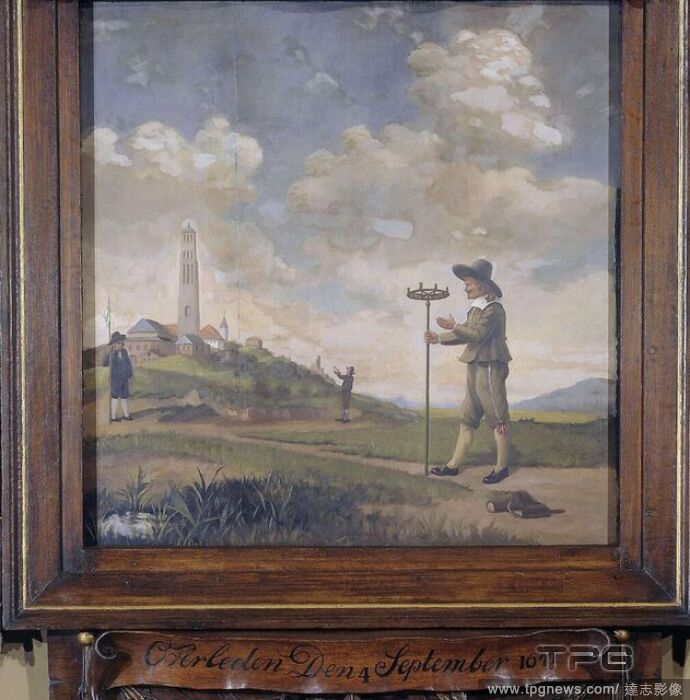
Editorial Portrait of a Surveyor (Andries van der Wal). Dating: 1650 - 1674. Place: Northern Netherlands. Measurements: h 88 cm ? w 87 cm.
- 2020-03-02
- 1
Editorial Portrait of a Surveyor (Andries van der Wal). Dating: 1650 - 1674. Place: Northern Netherlands. Measurements: h 88 cm ? w 87 cm.
- 2020-01-15
- 1
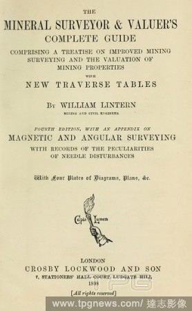
Editorial The mineral surveyor & valuer's complete guide : comprising a treatise on improved mining surveying and the valuation of mining properties with new traverse tables : Lintern, William.
- 2019-12-18
- 1
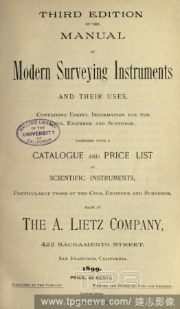
Editorial Manual of modern surveying instruments and their uses, containing useful information for the civil engineer and surveyor, together with a catalogue & price list of scientific instruments... made by the A. Lietz Company .. : Lietz, (A.), company.
- 2019-12-18
- 1

Editorial Design for a Freestanding Tomb Seen in Elevation and Plan.
- 2019-11-18
- 1
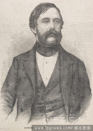
Editorial Fletcher Webster, Esq., Surveyor of Boston, 1859. Winslow Homer (American, 1836-1910). Wood engraving.
- 2019-04-01
- 1

Editorial Design for a Freestanding Tomb Seen in Elevation and Plan.
- 2019-02-15
- 1

Editorial Portrait of a Surveyor (Andries van der Wal). Dating: 1650 - 1674. Place: Northern Netherlands. Measurements: h 88 cm ? w 87 cm.
- 2019-01-25
- 1
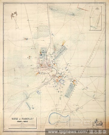
Editorial Siege of Kimberley. South Africa; 1900. [Whole map] Plan of the Siege of Kimberley, 14 October 1899 - 15 February 1900; with pictorial compass points showing speared Boers. Surveyed by Colonel A.J. O'Meara, R.E., and signed by Claude O. Lucas, Cape Gov...
- 2019-01-24
- 1
Editorial A plan of part of the coast of East Florida. A PLAN of Part of the Coast of EAST FLORIDA including S.t John's River from an actual Survey BY W.m Gerard De Brahm Esq.r SURVEYOR GENERAL of the Southern District of NORTH AMERICA. [London] : 1769, done by ...
- 2018-12-06
- 1

Editorial Siege of Kimberley. South Africa; 1900. [Whole map] Plan of the Siege of Kimberley, 14 October 1899 - 15 February 1900; with pictorial compass points showing speared Boers. Surveyed by Colonel A.J. O'Meara, R.E., and signed by Claude O. Lucas, Cape Gov...
- 2018-12-06
- 1
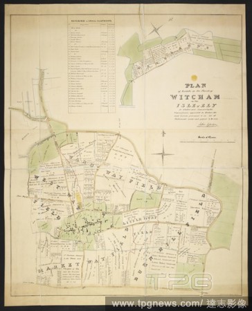
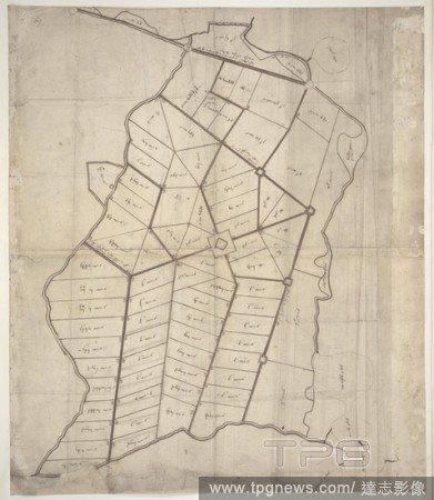
Editorial A plan of Lands in the Parish of Witcham in the Isle of Ely. Plan of Lands in the Parish of Witcham in the Isle of Ely, as allotted and awarded by the Commissioner appointed to inclose the said Lands ... 1838 Alexander Watford, Surveyor. Scale of chain...
- 2018-12-06
- 1
Editorial A plan of the River Kennebeck as it was surveyed by order of the Government of Massachusets Bay in the year MDCCLXI from the falls above Halifax unto the place where the surveyor John Small was killed, from his field book, with the addition of lower pa...
- 2018-12-06
- 1
Editorial A Plan of Part of the Marches of Calais. This plan shows a projected settlement near Calais, divided into allotments, with the admeasurements on each, and with roads and forts marked out. It was drawn in 1541 by the surveyor Richard Lee. 1541. Ink on v...
- 2018-12-06
- 1
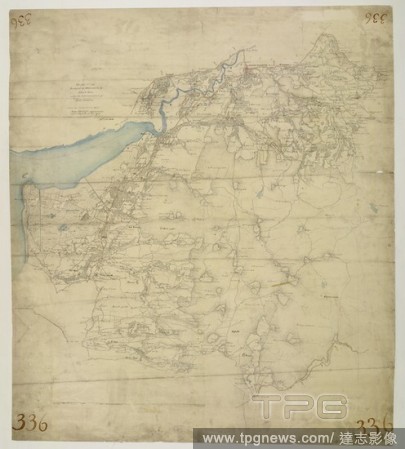
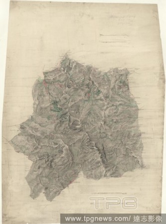
Editorial This drawing covers the boundary between the counties of Cardiganshire and Montgomeryshire. The border is marked as a red pecked line, following the course of the River Dovey for much of its length. Archaeological sites are noted in gothic script, an o...
- 2018-12-06
- 1
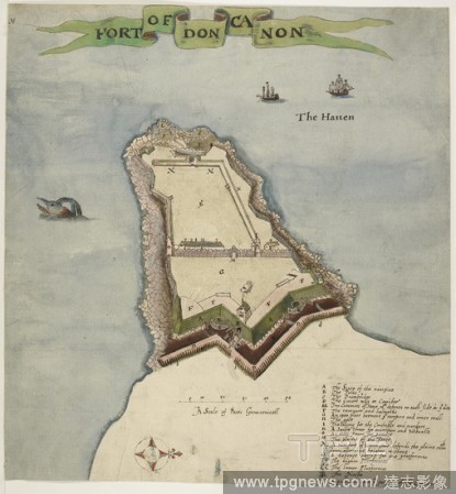
Editorial Duncannon Fort, County Wexford, Leinster, Ireland. This map shows Duncannon fort in County Wexford. It dates from around 1611 and is therefore contemporary with the English plantation scheme. This scheme aimed to establish an English colony in Ulster ...
- 2018-12-06
- 1
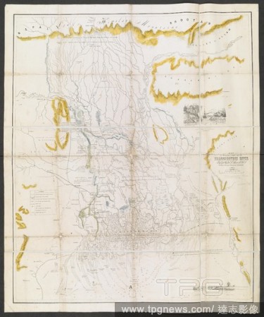
Editorial A map to illustrate a report upon the Bhaugiruthee River. Map to illustrate a report upon the Bhaugiruthee River, by Capt? W. S. Sherwill ... Scale, 16 miles to an inch. Calcutta : Surveyor General's Office, 1857. Source: Maps 53580.(27.). Language: ...
- 2018-12-06
- 1
Editorial Stourbridge. This plan covers parts of Worcestershire and Warwickshire. Hills and reliefs are illustrated by a combination of brushwork interlining ('hachures'), layering of colour washes and the use of aerial perspective. Tollroads are highlighted in ...
- 2018-12-06
- 1
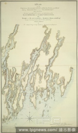
Editorial A plan of the coast from Kennebeck River to Round Pond. A PLAN OF THE COAST from KENNEBECK RIVER to ROUND POND on the WEST SIDE of MUSCONGUS BAY, including the ISLANDS, RIVERS, &c. within that Extent / Surveyed agreeably to the Orders and Instructions ...
- 2018-12-06
- 1

Editorial A map of Birmingham. To the Right Honourable William Earl of Dartmouth ... this Map of Birmingham engraved from a ... survey made in the years 1824 & 1825, is ... dedicated by ... Beilby, Knott & Beilby. J. Pigott Smith, Surveyor & Engineer. Birmingham...
- 2018-12-06
- 1

Editorial Design for a Freestanding Tomb Seen in Elevation and Plan.
- 2018-08-06
- 1

Editorial Abraham van der Doort (1575/1580-1640). Dutch artist, Surveyor of the Pictures of King Charles I. Portrait by William Dobson (1611-1646), late 1630s. The State Hermitage Museum. Saint Petersburg. Russia.
- 2018-07-30
- 1
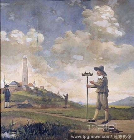
Editorial Portrait of a Surveyor, Andries van der Wal, Anonymous, 1650 - 1674.
- 2018-07-30
- 1

Editorial Sir Benjamin Rudgerd, surveyor.
- 2018-07-25
- 1
Editorial Mesopotamian Art. Kassite Dynasty. The Eanna-shum-iddina kudurru (1125-1100 B.C.). It describes the land grant made by Governor Eanna-shum-iddina to Gula-Eresh witnessed by his surveyor Amurru-Bel-Zeri. The bottom is inscribed in cuneiform script and ...
- 2018-07-24
- 1
 Loading