
filter
-
Brand
- By Category
- Direction
- Date Range
779Events
Pictures
Events
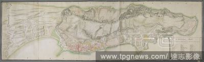
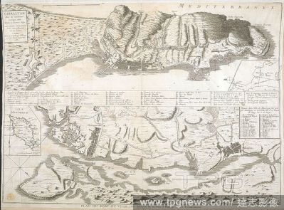
Editorial A plan of Gibraltar which includes the town, ports, moles, fortification, defences, magazines and position of batteries. A GENERAL PLAN OF THE CITY and PENINSULA of GIBRALTAR with the SPANISH LINES August 1742. [Gibraltar] : [James Gabriel Montresor], ...
- 2022-01-18
- 2

Editorial A plan of the isthmus, city and fortifications of Gibraltar. A colored "plan of the isthmus, city, and fortifications of Gibraltar, shewing elevations and sections of the principal public buildings, profiles through the two extremities of the rock, and...
- 2022-01-18
- 2
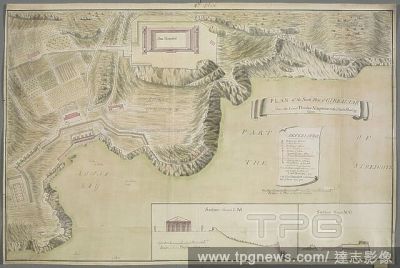
Editorial This plan includes the North Front of Gibraltar from the Moorish Castle to Prince's Lines and Wilis's batteries. PLAN of the NORTH FRONT of GIBRALTAR. [Gibraltar] : Capt Chas. OHara Coldstream Regt. Delineavit Iany. 1756., [1756.]. Source: Maps K.Top.7...
- 2022-01-18
- 1

Editorial Naval battle. Fürstellung der nach Gibraltar zum Entsatz bestimm. Nuremberg, [1705]. A naval battle. Image taken from Fürstellung der nach Gibraltar zum Entsatz bestimmten franz?sischen Flotte, unter dem Admiral Pointz wie sie von dem Admiral Lacke ...
- 2022-01-18
- 1

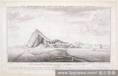
Editorial A view of the Rock of Gibraltar from the East, with Europa Point on the left, the Bay of Gibraltar on the right and a sailing ship in the foreground. VüE ORIENTAL DE GIBRALTAR DU C?Té DE LA MER MEDITERRANéé = The EAST VIEW of GIBRALTAR from the ME...
- 2022-01-18
- 1
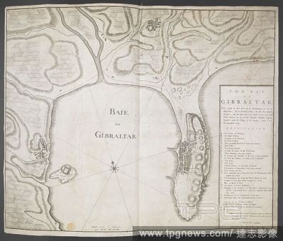
Editorial A map of the Bay of Gibraltar. Baie de Gibraltar. Carte de la Baye de Gibraltar. 1715?. Source: Maps K.Top.72.20. Language: French and English.
- 2022-01-18
- 1
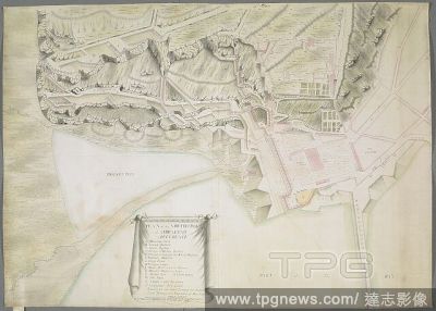
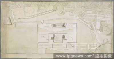
Editorial A plan of Rosia Bay, Gibraltar. Plan of ROSIA with the new Works by Order of Lord Tyrawly. [Gibraltar] : Capt: Rainsford of ye Coldstream Regt: Fecit., 1757. Source: Maps K.Top.72.47.m. Language: English.
- 2022-01-18
- 1

Editorial A view of the Rock of Gibraltar from the south-west, with four sailing ships and eight men on a barge in Rosia Bay, fortifications on the right and a Spanish tent in the background. Port of Gibraltar from Rosia Bay with the Spanish Camp during the Sieg...
- 2022-01-18
- 1

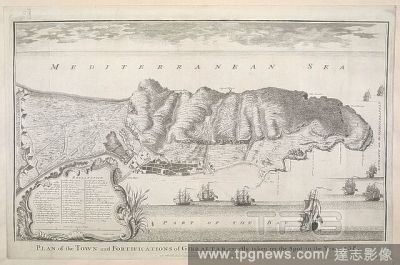
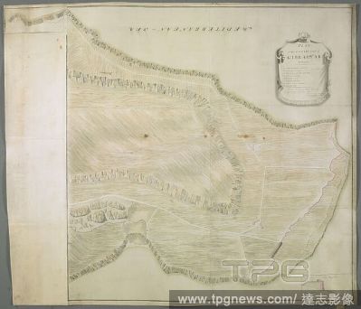
Editorial A plan of the peninsula and the city of Gibraltar, which shows the state of fortifications and defences at the time of the Great Siege of Gibraltar 1779-1783. PLAN OF THE PENINSULA & CITY OF GIBRALTAR : EXHIBITING our New Works and Batteries erected si...
- 2022-01-18
- 1
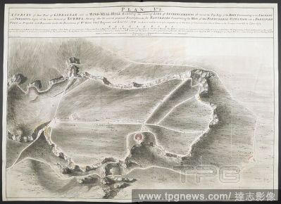
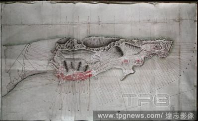
Editorial A survey of part of Gibraltar called the Windmill Hill. PLAN No: 3. A SURVEY of that Part of GIBRALTAR called the WIND-MILL-HILL Exhibiting the running LINE of ENTRENCHMENTS all round the Top Edge of the ROCK Commanding in an EMINENT and POWERFUL degre...
- 2022-01-18
- 1
Editorial A plan of Gibraltar. PLAN of GIBRALTAR : with the new additional Work's done By Order of The Right Honble: the LORD TYRAWLY are mark'd with Red Letter. [Gibraltar] : Lieut: Geo: Massey, of the 53d. Regt: Delineavit, September 1758. Source: Maps K.Top.7...
- 2022-01-18
- 1

Editorial A plan of Gibraltar which includes the town, ports, moles, fortification, defences, magazines and position of batteries . A GENERAL PLAN of the CITY and PENINSULA of GIBRALTAR. [London?] : [Tower of London Drawing Room?], 1747. Source: Maps K.Top.72.35...
- 2022-01-18
- 1
Editorial A view of Gibraltar from the West, with British sailing ships in the foreground . VüE OCCIDENTALE DE GIBRALTAR DU C?Té DE LA BAYE = THE WEST VIEW OF GIBRALTAR FROM THE BAY : To His Royal Highness WILLIAM Duke of Cumberland These four Perspective Vie...
- 2022-01-18
- 1
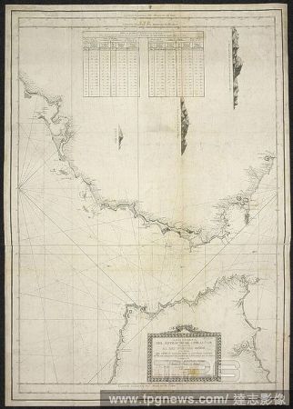
Editorial A nautical chart of the Straits of Gibraltar . Carta esfe?rica del estrecho de Gibraltar ... Construida por V. Tofin?o de San Miguel. [Madrid], 1786. Source: Maps * 18440.(11.).
- 2022-01-18
- 1
Editorial A map of Gibraltar. Below, a map of Port Mahon includes an inset of Minorca . GIBRALTAR : Avec les nouveaux ouvrages, faits depuis le dernier Siége. LES LIGNES ESPAGNOLES Levé nouvellement sur les Lieux. Paris : Chez le Sr. le Rouge, Ingr Gèogr. rue...
- 2022-01-18
- 1

Editorial This map includes the North Front of Gibraltar from an outline of the Spanish Lines to the Old Mole (A), with Grand battery ("North Polygon" (B)), Land Port (C), King's battery ("King's Line" (D)), Queen's battery and Devil's Tower . GIBRALTAR 1730 : A...
- 2022-01-18
- 1
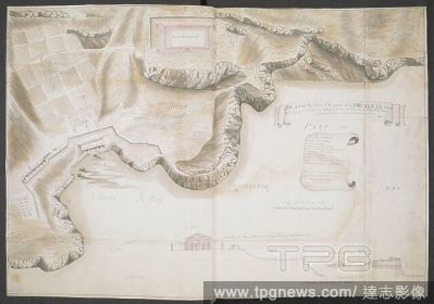
Editorial A plan of the South Part of Gibraltar. PLAN of the South Part of GIBRALTAR from the Great Powder Magazine to the Devils Bowling Green. [Gibraltar] : Capt: Cha: Rainsford Coldstream Regt: of Guards delint: 1758., [1758.]. Source: Maps K.Top.72.47.l.2.TA...
- 2022-01-18
- 2
Editorial A plan of the south part of Gibraltar from the Great Powder Magazine to the Devil's Bowling Green. PLAN of the SOUTH part of GIBRALTAR from the Great Powder Magazine to the Divils Bowling Green. [Gibraltar] : Capt. Charles O'Hara of the Coldstream Regi...
- 2022-01-18
- 1

Editorial A plan of the town and peninsula of Gibraltar, showing the Spaniards attack upon Gibraltar, as it was carried on from the beginning of the siege to the 25th Feb. 1726/7. A GENERAL PLAN of the TOWN and PENINSULA of GIBRALTAR. [London?] : [Tower of Londo...
- 2022-01-18
- 1
Editorial A view of Gibraltar from the North, with the isthmus in the foreground. The Mediterranen Sea on the left, fortifications and sailing ships on the right and the town of Ceuta and the coast of North Africa in the background. VüE SEPTENTRIONALE DE GIBRAL...
- 2022-01-18
- 1

Editorial A coloured plan of part of the northern portion of the town of Gibraltar, to show the "new store-house built by Mr. Denn" on the Esplanade. ca. 1731-1732. Source: Maps K.Top.72.46.a. Language: English.
- 2022-01-18
- 1
Editorial History of Spain. 18th century. Illustration depicting one of the sieges of Gibraltar. Spanish troops trying to recover the territory taken by the Anglo-Dutch coalition in 1704. Unsuccessful siege of Gibraltar. Chromolithography. "Historia General de E...
- 2022-01-18
- 3
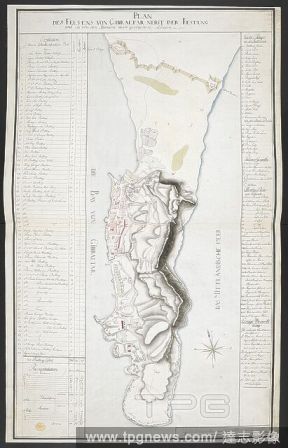
Editorial A plan of the Rock of Gibraltar beside the Fortress. Includes the town, moles, fortifications, defences, magazines and position of batteries. PLAN DES FELSENS VON GIBRALTAR NEBST DER FESTUNG : und die von den Spaniern davor gezogenen Linien. [Germany?]...
- 2022-01-18
- 1

Editorial A plan of Gibraltar. The map includes the town, ports, moles, fortification, defences, batteries, magazines and windmills . Geometrical Plan of the Town Moutain, and Bay of Gibraltar as now fortified by Colonel J.B. [Gibraltar?] : [producer not identif...
- 2022-01-18
- 1

Editorial A view of the south side of Gibraltar from the coast of Africa, with sailing ships in the Strait . VüE MERIDIONALE DE GIBRALTAR, DEPUIS LE DETROIT PR?CHé LA MONTAGNE DE SINGES EN BARBARIE. = The SOUTH VIEW of GIBRALTAR from the STREIGHTS near Apes-H...
- 2022-01-18
- 1

Editorial A plan of the bay and town of Gibraltar. THE BAY of GIBRALTAR. [England] : [producer not identified], [between 1690 and 1720?]. Source: Maps K.Top.72.21. Language: English.
- 2022-01-18
- 1
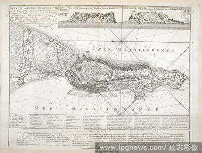
Editorial A geometrical map of Gibraltar . Plan Ge?ome?tral de Gibraltar avec les nouveaux ouvrages de cette Ville faits par les Anglois; par le Chevr de Beaurain: avec deux Vues, et und Description. 1756. Source: Maps K.Top.72.37. Language: French.
- 2022-01-18
- 1
Editorial A plan of the town and fortifications of Gibraltar. Plan of the Town and Fortifications of Gibraltar, exactly taken on the spot in the year 1738. Scale of one English mile[ = 135 mm]. London : Printed for John and Paul Knapton, 1745. Source: Maps K.Top...
- 2022-01-18
- 1

Editorial A view of the Rock of Gibraltar from the North, with the coast of Africa and Ceuta on the left, Devil's Tower and Guard's House on the beach in the foreground. Moorish Castle, the British flag flying over the Grand Battery and Old Mole on the right; sa...
- 2022-01-18
- 1

Editorial A map and a view of Gibraltar, produced on two sheets assembled and mounted together. A Plann of Gibraltar near Streights-Mouth over against Ceuta in Affrica. [England] : [Martin Beckman], [1701.]. Source: Maps K.Top.72.22.2.TAB. Language: English.
- 2022-01-18
- 2

Editorial A coloured plan of the town and mountains of Gibraltar, in a German hand, showing the state of the fortifications on April 15th, 1726. 1726. Source: Maps K.Top.72.29. Language: English.
- 2022-01-18
- 1

Editorial A map of the coast of Spain, and two insets with soundings: "The Bay & City of Gibraltar in Spain" and "The Harbour of Port Mahon" . A MAP of the Coast of SPAIN, from the Streights of GIBRALTAR; to the Gulf of CARTAGENA. London : Sold by by H: Overton ...
- 2022-01-18
- 1

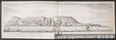
Editorial A view of Gibraltar from the South West, with sailing ships in the Bay of Algeciras seen beyond the New Mole Fort in the foreground. The Spanish coast and hills can be seen on the left, Moorish castle and bastions in the middle, battery and remains of ...
- 2022-01-18
- 1

Editorial A view of the Rock of Gibraltar from the West, with details of the fort, garrison and sailing ships in the foreground. View of the west front of Gibraltar. c. 1710. Source: Maps K.Top.72.48.b.
- 2022-01-18
- 1
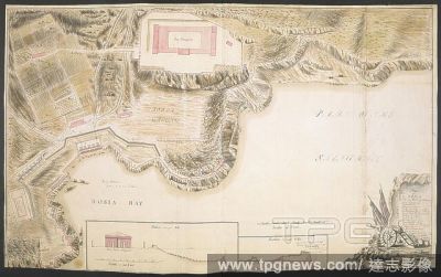
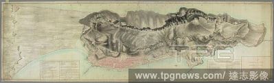
Editorial A plan of the south part of Gibraltar, which includes Europa and Wind Mill Hill, fortifications and defences. PLAN of the SOUTH Part of GIBRALTAR. [Gibraltar] : Lieutenant Geo: Massey of General Whitmore's Regt: Delineavit, [1756-1757.]. Source: Maps K...
- 2022-01-18
- 1
Editorial A map showing the state of fortifications and defences at the time of the Great Siege of Gibraltar 1779-1783, during which undisturbed work was going on to strengthen the defences . PLAN OF THE PENINSULA & CITY OF GIBRALTAR : EXHIBITING our New Works a...
- 2022-01-18
- 1
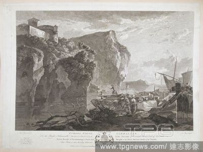
Editorial A view of the Rock of Gibraltar with barges and merchants in Oriental costume in the foreground. Europa Point, Gibraltar : To the Right Honourable FRANCIS GREVILLE, EARL BROOKE of Warwick Castle, Earl of Warwick, Baron Brooke of Beauchamp's Court, and ...
- 2022-01-18
- 1
Editorial A plan of the peninsula and city of Gibraltar. This plan includes the town, moles, fortifications, defences, magazines and position of batteries. PLAN of the PENINSULA and CITY of GIBRALTAR. 1735. [Gibraltar] : William Test. Delt: 1778., [between 1735 ...
- 2022-01-18
- 1

Editorial An exact plan of the fortifications of Gibraltar. A colored "exact plan of the fortifications of Gibraltar, 1723;" drawn on a scale of 200 feet to an inch. 1723. Source: Maps K.Top.72.27. Language: English.
- 2022-01-18
- 1
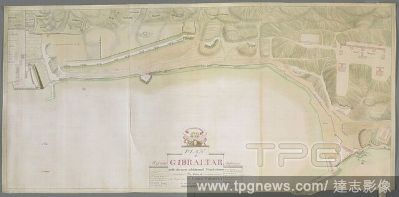
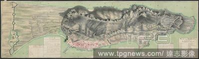
Editorial A plan of Gibraltar from the South Port to the New Mole. PLAN of GIBRALTAR from the SOUTH PORT to the NEW MOLE. [Gibraltar] : Lieut: Massey of Col. Whitmore's Regt: Delineavit, [1756-1757.]. Source: Maps K.Top.72.47.h.2.TAB. Language: English.
- 2022-01-18
- 1

Editorial A view of Gibraltar from the south, with three sailing ships in the foreground. The Rock of Gibraltar in standing thro' the Streights. c. 1780. Watercolour. Source: Maps K.Top.72.48.k.
- 2022-01-18
- 1

Editorial SITIO DE GIBRALTAR. 1779-1783. REINADO DE CARLOS III ( 1759 - 1788 ). GRABADO DEL A?O 1782.
- 2022-01-18
- 1

Editorial Antonio Barcel? y Pont de la Terra (Galilea, isla de Mallorca, 1717-Ibidem, 1797) fue un marino y militar espa?ol, teniente general de la Real Armada Espa?ola. Inventor de las ca?oneras durante el Gran asedio a Gibraltar (1779 1783). Grabado de 1896.
- 2022-01-18
- 1

Editorial CARTA DE LA BAHIA DE GIBRALTAR, 1779.
- 2022-01-18
- 1

Editorial PLANO DE GIBRALTAR - 1782 - Escala 1:12.000.
- 2022-01-18
- 1

Editorial PUERTA DE LAS CASAMATAS O CASEMATES GATES ABIERTA EN 1727 - FOTO A?OS 00.
- 2022-01-18
- 1

Editorial VISTA DE GIBRALTAR LEVANTADA SOBRE LOS MAS EXACTOS PLANOS Y DOCUMENTOS DE 1782.
- 2022-01-18
- 1

Editorial H ESPA?A-RENDICION DE GIBRALTAR EN 1704 - TOMA DEL PE?ON POR LOS INGLESES -.
- 2022-01-18
- 1

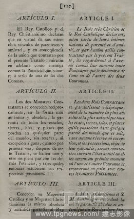
Editorial TRATADO DE UTRECH(1713) ART 9-10 CESION GIBRALTAR.
- 2022-01-18
- 7

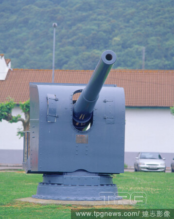
Editorial CA?ON QUE EN 1782 DEFENDIO EL SITIO DE GIBRALTAR.
- 2022-01-18
- 1

Editorial SITIO DE GIBRALTAR POR LAS TROPAS ESPA?OLAS EN 1727-GRABADO ALEMAN.
- 2022-01-18
- 1
Editorial SITIO DE GIBRALTAR - LANCHA CA?ONERA - SIGLO XVIII.
- 2022-01-18
- 2
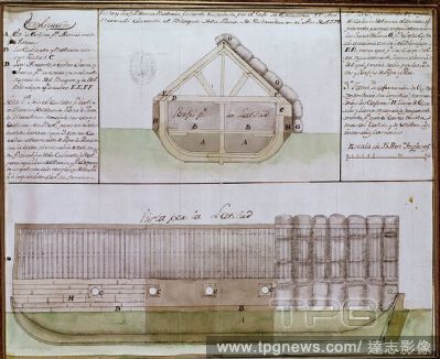
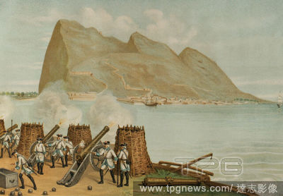
Editorial VISTA Y PERFIL DE BATERIA FLOTANTE DISPUESTA DURANTE EL BLOQUEO DE LA PLAZA DE GIBRALTAR 1779.
- 2022-01-18
- 1

Editorial Planned attacks on a part of the Strait of Gibraltar until 15 February 1705. Madrid, Military historical archives.
- 2022-01-18
- 1
Editorial PLANO PARA ATAQUE A GIBRALTAR-POR EL DUQUE DE CRILLON-1779.
- 2022-01-18
- 1
Editorial Gibraltar. General view. Engraving by Antonio Roca Sallent. Later colouration. Las Glorias Nacionales, 1853.
- 2022-01-18
- 1
Editorial Treaty of Paris (III Family Compact). Treaty between King Charles III of Spain and King Louis XVI of France, signed in Paris on 15 August 1761. It meant Spain's involvement in the final phase of the Seven Years' War (1756-1763), with the purpose of rec...
- 2022-01-18
- 2
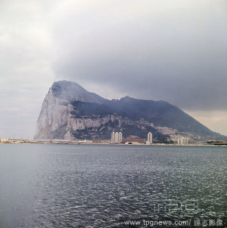
Editorial EL PE?ON DE GIBRALTAR - FOTO A?OS 60.
- 2022-01-18
- 6
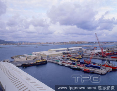
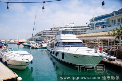
Editorial PUERTO COMERCIAL CON LA LINEA DE LA CONCEPCION AL FONDO - FOTO A?OS 00.
- 2022-01-18
- 1

Editorial TIENDA LIBRE DE IMPUESTOS EN LA CALLE PRINCIPAL O CALLE MAYOR - FOTO A?OS 00.
- 2022-01-18
- 13

Editorial April Ashley's marriage void
- 2021-12-30
- 1

Editorial World Cup 2022 Qualifaction group G match between Turkey and Gibraltar at Basaksehir Fatih Terim Stadium in Istanbul , Turkey on November 13 , 2021
- 2021-11-15
- 444

Editorial Fifa World Cup 2022 Qualifying Round - Europe Group G : Netherlands 6-0 Gibraltar
- 2021-10-13
- 64

Editorial Martin Zamora, left, and his son Martin Jr. prepare the body of a migrant who drowned in the Mediterranean Sea, at their mortuary in Algeciras, Spain, June 23, 2021. (Samuel Aranda/The New York Times)
- 2021-10-13
- 10

Editorial Netherlands v Gibraltar, FIFA World Cup Qualifier, Feyenoord Stadium de Kuip, Rotterdam, The Netherlands - 11 Oct 2021
- 2021-10-12
- 9

Editorial Netherlands: Netherlands vs Gibraltar
- 2021-10-12
- 277
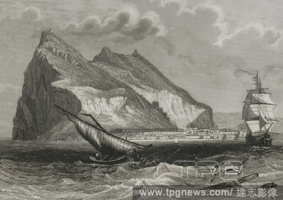
Editorial Gibraltar. Panoramic view. Engraving. Later colouration. Cronica General de Espa?a, Historia Ilustrada y Descriptiva de sus Provincias. Andalucia, 1867.
- 2021-10-09
- 1

Editorial Vista panor?mica del estrecho de Gibraltar. Grabado de 1856.
- 2021-10-09
- 1

Editorial Pen?nsula Ib?rica. Vista de Gibraltar. Grabado. Coloreado. Cr?nica General de Espa?a, Historia Ilustrada y Descriptiva de sus Provincias. Andaluc?a, 1867.
- 2021-10-09
- 1

Editorial Gibraltar. Panoramic view. Engraving. Cronica General de Espa?a, Historia Ilustrada y Descriptiva de sus Provincias. Andalucia, 1867.
- 2021-10-09
- 1
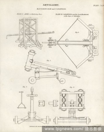
Editorial Artillery: Aries or wooden battering ram and catapult used by Lord Heathfield at the siege of Gibraltar. Copperplate engraving by Wilson Lowry from Abraham Rees' Cyclopedia or Universal Dictionary of Arts, Sciences and Literature, Longman, Hurst, Rees,...
- 2021-10-09
- 1
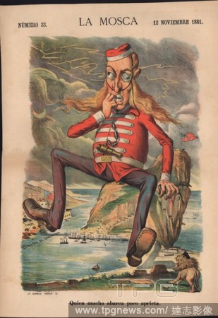
Editorial Portada del diario sat?rico La Mosca. Dibujo jocoso sobre la situaci?n pol?tica del pe??n de Gibraltar. Barcelona, a?o 1881.
- 2021-10-09
- 1
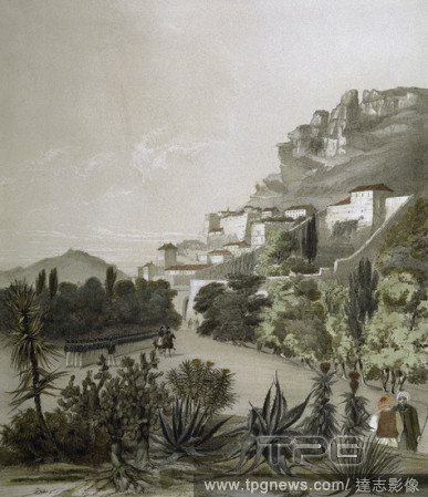
Editorial HISTORIA DE GIBRALTAR. "Gibraltar" (1837).. Dibujo de David Roberts, litograf?a de W. Gauci. Londres, 1837.
- 2021-10-09
- 1
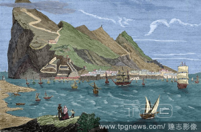
Editorial Gibraltar. View from the boulevard. Drawing by George Vivian. Litography by T.S. Boys. London, 1838.
- 2021-10-09
- 1
Editorial Gibraltar. View from The Anchorage. Drawing by Nicolas Chapuy. Lithography by Cuvillier. Paris, 1844.
- 2021-10-09
- 1

Editorial DIBUJO DEL ESTRECHO DE GIBRALTAR A VISTA DE PAJARO- S XIX.
- 2021-10-09
- 1
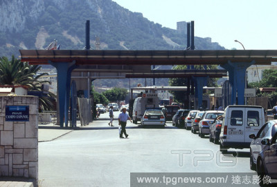
Editorial COCHES ESPERANDO ENTRAR EN LA ADUANA.
- 2021-10-09
- 2

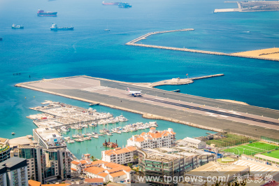
Editorial EL PUERTO DE GIBRALTAR Y LA BAHIA DE ALGECIRAS DESDE LO ALTO DEL PE?ON - FOTO A?OS 60.
- 2021-10-09
- 1
Editorial Gibraltar. General view. Engraving by Antonio Roca Sallent. Las Glorias Nacionales, 1853.
- 2021-10-09
- 1

Editorial Heemskerck's Victory Over the Spanish Fleet at Gibraltar. Dated: 1634. Dimensions: plate (partially trimmed to plate mark): 12.4 x 15.6 cm (4 7/8 x 6 1/8 in.) sheet: 12.5 x 17.1 cm (4 15/16 x 6 3/4 in.). Medium: etching and engraving on laid paper.
- 2021-10-09
- 1

Editorial Netherlands: Persconference Louis van Gaal
- 2021-10-05
- 124

Editorial Daily life in Gibraltar, UK - 20 Aug 2021
- 2021-08-21
- 33

Editorial Daily life in Gibraltar, UK - 20 Aug 2021
- 2021-08-21
- 50
Editorial Daily life in Gibraltar, UK - 20 Aug 2021
- 2021-08-21
- 50
Editorial Daily life in Gibraltar, UK - 20 Aug 2021
- 2021-08-21
- 133

Editorial UEFA Womens International Friendly - Liechtenstein v Gibraltar
- 2021-07-03
- 46
Editorial CA?ON GUARDACOSTAS - INSTALADO ANTERIORMENTE EN EL ESTRECHO DE GIBRALTAR.
- 2021-04-07
- 2

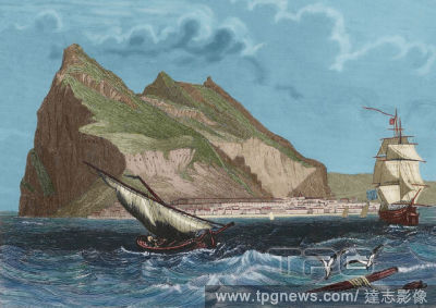
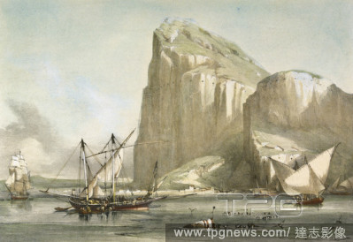
Editorial Felucca off Gibraltar. Dated: mid 19th century. Dimensions: overall: 55.8 x 76.6 cm (21 15/16 x 30 3/16 in.) framed: 72 x 92.4 x 7.6 cm (28 3/8 x 36 3/8 x 3 in.). Medium: oil on canvas.
- 2021-04-07
- 1

Editorial First map of Africa (Straits of Gibraltar, northwest Africa), in full gold border., still image, Religious books, 1460, Ptolemy, 2nd cent., Nicolaus Germanus (15th cent.).
- 2021-04-07
- 1

Editorial Spain lifts restrictions on land access to Gibraltar
- 2021-04-01
- 14

Editorial Gibraltar: Gibraltar vs Netherlands
- 2021-03-31
- 147
 Loading